
Make a donation
Gear up for your next adventure:
As an Amazon Associate, this site earns from qualifying purchases at no extra cost to you.
Gilmanton topographic map
Click on the map to display elevation.
Make a donation
Gear up for your next adventure:
As an Amazon Associate, this site earns from qualifying purchases at no extra cost to you.
Gilmanton
The town is served by four state routes: 106, 129, 107 and 140. Route 107 is part of Old Province Road, an important road in New Hampshire's early history, and Route 106 is a well-traveled connection between Laconia and Concord. Route 140 is an east-west highway leading from Tilton to Alton. The intersection NH 107 and NH 140 is at Gilmanton Corners, one of the two major villages. Gilmanton Corner (or simply "Gilmanton", as shown on topographic maps) is the location of several historic buildings, including Gilmanton Academy and Centre Congregational Church. Gilmanton Ironworks is located in the eastern part of town along NH 140, near the outlet of Crystal Lake.
Make a donation
Gear up for your next adventure:
As an Amazon Associate, this site earns from qualifying purchases at no extra cost to you.
About this map
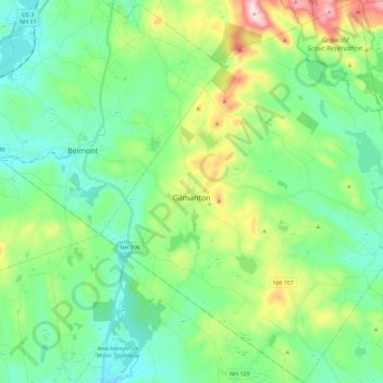
Name: Gilmanton topographic map, elevation, terrain.
Location: Gilmanton, Belknap County, New Hampshire, United States (43.34645 -71.46796 43.50941 -71.26561)
Average elevation: 843 ft
Minimum elevation: 423 ft
Maximum elevation: 2,021 ft
Belknap County trails, hiking, mountain biking, running and outdoor activities
Make a donation
Gear up for your next adventure:
As an Amazon Associate, this site earns from qualifying purchases at no extra cost to you.
Other topographic maps
Click on a map to view its topography, its elevation and its terrain.
Governors Island
United States > New Hampshire > Belknap County > Gilford > Dockham Shore
Average elevation: 531 ft
Diamond Island
United States > New Hampshire > Belknap County > Gilford > Coleman Point
Average elevation: 505 ft
Rattlesnake Island
United States > New Hampshire > Belknap County > Alton
Rattlesnake Island is about 2 miles (3 km) long, and approximately 5 miles (8 km) around its shore. The topography varies greatly. Some sections of the island are quite steep, with the land rising steeply from the shore (affording views of the area), while other sections, particularly on the "peninsula", which…
Average elevation: 522 ft
Make a donation
Gear up for your next adventure:
As an Amazon Associate, this site earns from qualifying purchases at no extra cost to you.
Halfmoon Lake
United States > New Hampshire > Belknap County > Barnstead > Fernhill
Average elevation: 699 ft
Make a donation
Gear up for your next adventure:
As an Amazon Associate, this site earns from qualifying purchases at no extra cost to you.
Make a donation
Gear up for your next adventure:
As an Amazon Associate, this site earns from qualifying purchases at no extra cost to you.
Sleepers Island
United States > New Hampshire > Belknap County > Alton > Smith Point
Average elevation: 535 ft
Gilmanton Ironworks
United States > New Hampshire > Belknap County > Gilmanton
Average elevation: 735 ft
Make a donation
Gear up for your next adventure:
As an Amazon Associate, this site earns from qualifying purchases at no extra cost to you.
Gunstock Mountain
United States > New Hampshire > Belknap County > Gilford
Average elevation: 1,496 ft
Make a donation
Gear up for your next adventure:
As an Amazon Associate, this site earns from qualifying purchases at no extra cost to you.