Geolocate

Antlers topographic map

Click on the map to display elevation.

About this map

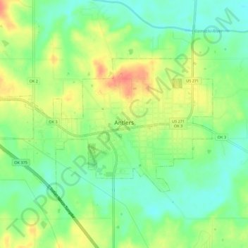
Name: Antlers topographic map, elevation, terrain.

Location: Antlers, Pushmataha County, Oklahoma, United States (34.21847 -95.65563 34.24556 -95.60097)

Average elevation: 505 ft

Minimum elevation: 433 ft

Maximum elevation: 597 ft

Pushmataha County trails, hiking, mountain biking, running and outdoor activities

Other topographic maps

Click on a map to view its topography, its elevation and its terrain.

Sardis

United States > Oklahoma > Pushmataha County

Average elevation: 617 ft

Kiamichi

United States > Oklahoma > Pushmataha County > Kiamichi

Average elevation: 715 ft

Gear up for your next adventure:

🥾Women's Hiking Boots - Top-rated trail boots with ankle support and superior grip
🥩Freeze-Dried Meals - Nutritious and lightweight food for remote expeditions
🦟Ultrasonic Repellers - Create a bug-free zone at your camp or rest stop
🧥Men's Rain Shells - Premium waterproof and breathable jackets for mountain weather
🪶Paracord Bracelet - Survival bracelet with built‑in tools

As an Amazon Associate, this site earns from qualifying purchases at no extra cost to you.