
Arborg topographic map
Click on the map to display elevation.
About this map
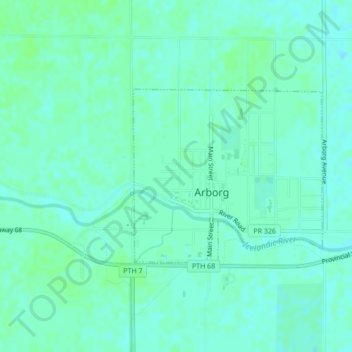
Name: Arborg topographic map, elevation, terrain.
Location: Arborg, Division No. 18, Manitoba, R0C 0A0, Canada (50.90252 -97.22773 50.91584 -97.20472)
Average elevation: 755 ft
Minimum elevation: 741 ft
Maximum elevation: 764 ft
Other topographic maps
Click on a map to view its topography, its elevation and its terrain.
Clear Lake
Canada > Manitoba > Division No. 18 > Rural Municipality of Grahamdale
Average elevation: 823 ft
Icelandic River
Canada > Manitoba > Division No. 18 > Rural Municipality of Bifrost – Riverton
Average elevation: 764 ft
Poplarfield
Canada > Manitoba > Division No. 18 > Rural Municipality of Fisher
Average elevation: 886 ft
Inwood
Canada > Manitoba > Division No. 18 > Rural Municipality of Armstrong
Average elevation: 906 ft
Moosehorn
Canada > Manitoba > Division No. 18 > Rural Municipality of Grahamdale
Average elevation: 873 ft
Hecla
Canada > Manitoba > Division No. 18 > Unorganized Division No. 18 (East)
Average elevation: 722 ft
Riverton
Canada > Manitoba > Division No. 18 > Rural Municipality of Bifrost – Riverton
Average elevation: 725 ft