
Make a donation
Gear up for your next adventure:
As an Amazon Associate, this site earns from qualifying purchases at no extra cost to you.
Fairford topographic map
Click on the map to display elevation.
Make a donation
Gear up for your next adventure:
As an Amazon Associate, this site earns from qualifying purchases at no extra cost to you.
About this map
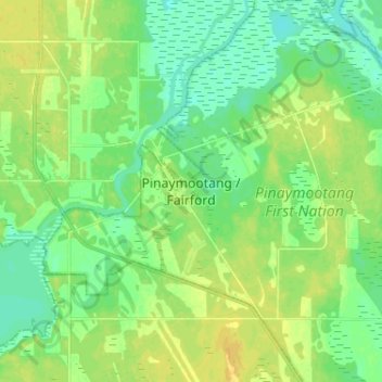
Name: Fairford topographic map, elevation, terrain.
Location: Fairford, Division No. 18, Manitoba, R0C 0X0, Canada (51.55240 -98.72468 51.63240 -98.64468)
Average elevation: 823 ft
Minimum elevation: 794 ft
Maximum elevation: 856 ft
Make a donation
Gear up for your next adventure:
As an Amazon Associate, this site earns from qualifying purchases at no extra cost to you.
Other topographic maps
Click on a map to view its topography, its elevation and its terrain.
Clear Lake
Canada > Manitoba > Division No. 18 > Rural Municipality of Grahamdale
Average elevation: 823 ft
West Shoal Lake
Canada > Manitoba > Division No. 18 > Rural Municipality of St. Laurent
Average elevation: 860 ft
Icelandic River
Canada > Manitoba > Division No. 18 > Rural Municipality of Bifrost – Riverton
Average elevation: 764 ft
Make a donation
Gear up for your next adventure:
As an Amazon Associate, this site earns from qualifying purchases at no extra cost to you.