
Silleda topographic map
Interactive map
Click on the map to display elevation.
About this map
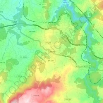
Name: Silleda topographic map, elevation, terrain.
Location: Silleda, Deza, Pontevedra, Galicia, España (42.65798 -8.28664 42.73798 -8.20664)
Average elevation: 1,427 ft
Minimum elevation: 876 ft
Maximum elevation: 2,398 ft
Other topographic maps
Click on a map to view its topography, its elevation and its terrain.
Monte Carrio
Monte Carrio, Lalín, Deza, Pontevedra, Galicia, 36596, España
Average elevation: 2,247 ft
San Salvador de Camba
San Salvador de Camba, Rodeiro, Deza, Pontevedra, Galicia, 36539, España
Average elevation: 2,425 ft
A Bandeira
A Bandeira, Silleda, Deza, Pontevedra, Galicia, 36570, España
Average elevation: 1,102 ft
Santa Baia
España > Galicia > Deza > Santa Baia
Santa Baia, Santa Baia de Camba, Rodeiro, Deza, Pontevedra, Galicia, 36537, España
Average elevation: 2,589 ft
Vila de Cruces
Vila de Cruces, Deza, Pontevedra, Galicia, 36590, España
Average elevation: 1,483 ft