
Lalín topographic map
Click on the map to display elevation.
About this map
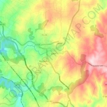
Name: Lalín topographic map, elevation, terrain.
Location: Lalín, Deza, Pontevedra, Galicia, 36519, España (42.62141 -8.15098 42.70141 -8.07098)
Average elevation: 1,900 ft
Minimum elevation: 1,404 ft
Maximum elevation: 2,438 ft
Other topographic maps
Click on a map to view its topography, its elevation and its terrain.
Lalín
El relieve del municipio está caracterizado por el valle del río Deza, afluente del río Ulla,que hace de límite por el oeste con el municipio de Silleda. Sin embargo, limitando el valle, también cuenta con zonas montañosas, destacando los Montes de Testeiro y la sierra de O Candán al suroeste, donde se…
Average elevation: 1,886 ft
Silleda
El relieve del municipio está caracterizado por el valle del río Deza hasta su desembocadura en el río Ulla y por las montañas que lo circundan. Varios son los puntos geográficos que marcan el territorio, destacando la sierra de Candán (1015 metros) y el Monte Chamor (824 metros) al sur, así como San…
Average elevation: 1,581 ft
Dozón
El relieve del municipio es montañoso, entre cuyas elevaciones discurren ríos y regatos, destacando el río Asneiro, afluente del río Deza. Destacan los montes Pena de Francia (914 metros), Gándara (867 metros) y A Rocha (813 metros). La altitud del municipio oscila entre los 914 metros (Monte da Pena de…
Average elevation: 2,238 ft
ZEC Serra do Candán
Las principales cumbres son el alto de san Benito (1017 metros), El Coco (969 metros), Seixiños Blancos (905 metros), Chamor (815 metros) y Alto de San Sebastián (750 metros). La sierra del Candán está incluida en la Red Natura por la riqueza de sus ecosistemas, que varían desde los bosques de galería…
Average elevation: 2,195 ft