
Lancaster topographic map
Click on the map to display elevation.
Lancaster
Just south of the village center is Mount Prospect, summer home to Senator John W. Weeks, who sponsored congressional legislation creating White Mountain National Forest. In 1910, he purchased several farms to assemble the 420-acre (170 ha) estate. It is now Weeks State Park, which features a fire lookout and his mansion, open for tours during the summer. The Mount Prospect Ski Tow operates on the slope in winter, snow conditions permitting. Many of the White Mountains and Green Mountains can be seen from the stone observation tower built in 1912 atop the 2,059-foot (628 m) summit. The Presidential Range is to the southeast, with the Franconia Range to the south. Mount Weeks, elevation 3,900 ft (1,200 m), is in the Kilkenny Range to the northeast. It is named for the senator, as is the Weeks Medical Center. Weeks Memorial Library, a Beaux Arts landmark listed on the National Register of Historic Places in 2000, was given by John W. Weeks in memory of his father, William Dennis Weeks.
About this map
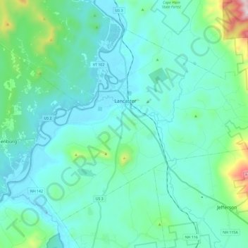
Name: Lancaster topographic map, elevation, terrain.
Location: Lancaster, Coös County, New Hampshire, 03584, United States (44.41019 -71.66063 44.53864 -71.42977)
Average elevation: 1,217 ft
Minimum elevation: 810 ft
Maximum elevation: 3,625 ft
Coos County trails, hiking, mountain biking, running and outdoor activities
Other topographic maps
Click on a map to view its topography, its elevation and its terrain.
Jefferson Highland
United States > New Hampshire > Coos County > Jefferson > Jefferson Highland
Average elevation: 1,480 ft
LIttle Diamond Pond
United States > New Hampshire > Coos County > Stewartstown
Average elevation: 2,274 ft
Wildcat Mountain
United States > New Hampshire > Coos County
Wildcat Mountain has five summits — A, B, C, D, and E — along Wildcat Ridge, which curves two miles (3 km) to the south and west. Both A, at 4,422 feet (1,348 m), and D, at 4,062 feet (1,238 m), are considered "four-thousand footers". B, with an elevation of 4,305 feet (1,312 m), and C, at 4,285 feet…
Average elevation: 3,461 ft
Pinkham Notch
United States > New Hampshire > Coos County
Pinkham Notch (elevation 2032 ft. / 619 m) is a mountain pass in the White Mountains of north-central New Hampshire, United States. The notch is a result of extensive erosion by the Laurentide Ice Sheet during the Wisconsinian ice age. Pinkham Notch was eroded into a glacial U-shaped valley whose walls are…
Average elevation: 2,516 ft