Geolocate

Condove topographic map

Click on the map to display elevation.

About this map

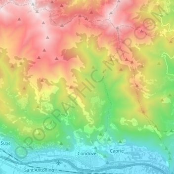
Name: Condove topographic map, elevation, terrain.

Location: Condove, Turin, Piedmont, 10055, Italy (45.10753 7.20368 45.19763 7.33436)

Average elevation: 3,917 ft

Minimum elevation: 1,148 ft

Maximum elevation: 7,858 ft

Other topographic maps

Click on a map to view its topography, its elevation and its terrain.

Prarotto

Italy > Piedmont > Turin > Condove

Average elevation: 3,904 ft

Turin

Italy > Piedmont > Turin

Average elevation: 968 ft

Blanc

Italy > Piedmont > Turin > San Germano Chisone

Average elevation: 2,726 ft

Turin

Italy > Piedmont > Turin

Average elevation: 968 ft

Sportinia

Italy > Piedmont > Turin > Sauze d'Oulx

Average elevation: 6,611 ft

La Cialma

Italy > Piedmont > Turin > Locana

Average elevation: 5,594 ft

Pratobotrile

Italy > Piedmont > Turin > Condove

Average elevation: 3,665 ft

Turin

Italy > Piedmont > Turin

Average elevation: 968 ft

Rivetto

Italy > Piedmont > Turin > San Giorio di Susa

Average elevation: 1,913 ft

Magnoletto

Italy > Piedmont > Turin > Condove

Average elevation: 2,293 ft

Suppo

Italy > Piedmont > Turin > Rubiana

Average elevation: 4,429 ft

Tornetti

Italy > Piedmont > Turin > Viù

Average elevation: 4,373 ft

Baio Dora

Italy > Piedmont > Turin

Average elevation: 1,621 ft

Famolasco

Italy > Piedmont > Turin

Average elevation: 1,667 ft

Morelli

Italy > Piedmont > Turin > Gravere

Average elevation: 2,575 ft

Belvedere

Italy > Piedmont > Turin > Borgiallo

Average elevation: 2,405 ft

Gear up for your next adventure:

🔦LED Headlamp - Bright and durable LED headlamp for night navigation
🥄Camping Utensil Set - Lightweight utensils for outdoor meals
🪶Wildlife Field Guides - Learn animal tracking and species ID
🧼Biodegradable Camping Soap - Eco‑friendly soap for outdoor hygiene
Backpacking Tents - Weight-optimized shelters for multi-day topographic surveys

As an Amazon Associate, this site earns from qualifying purchases at no extra cost to you.