Geolocate

Grad Cres topographic map

Click on the map to display elevation.

About this map

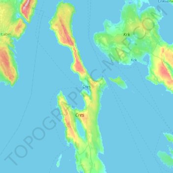
Name: Grad Cres topographic map, elevation, terrain.

Location: Grad Cres, Primorje-Gorski Kotar County, Croatia (44.74419 14.27247 45.17571 14.48654)

Average elevation: 203 ft

Minimum elevation: -13 ft

Maximum elevation: 2,638 ft

Other topographic maps

Click on a map to view its topography, its elevation and its terrain.

Crikvenica

Croatia > Primorje-Gorski Kotar County

Average elevation: 377 ft

Rijeka

Croatia > Primorje-Gorski Kotar County

Average elevation: 1,266 ft

Grahovo

Croatia > Primorje-Gorski Kotar County

Average elevation: 1,745 ft

Begovo Razdolje

Croatia > Primorje-Gorski Kotar County

Begovo Razdolje (Croatian pronunciation: [bɛ̂ɡɔʋɔ rǎːzdɔːʎɛ]) is a village in Mrkopalj municipality, Primorje-Gorski Kotar County, Croatia. At 1,060 m (3,478 ft), it is the settlement with the highest elevation in Croatia.

Average elevation: 3,560 ft

Divjake

Croatia > Primorje-Gorski Kotar County

Average elevation: 2,290 ft

Gear up for your next adventure:

🛠️Outdoor Gear Repair Kit - Essential tools to fix gear on the trail
🏫Relief Map Kits - Hands-on tools for teaching landforms and elevation
🥤Water Filter Bottle - All‑in‑one filter bottle for safe hydration
📶Vehicle Signal Boosters - Improve reception in rural areas while driving to trailheads
🪶Survival Guide Book - Expert advice for emergency preparedness

As an Amazon Associate, this site earns from qualifying purchases at no extra cost to you.