Geolocate

Kapas Island topographic map

Click on the map to display elevation.

About this map

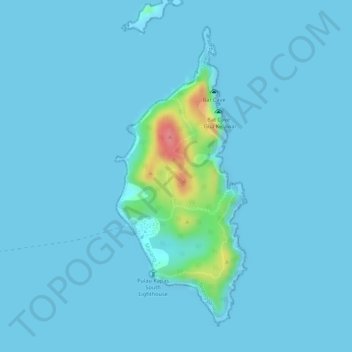
Name: Kapas Island topographic map, elevation, terrain.

Location: Kapas Island, Marang, Terengganu, Malaysia (5.20949 103.26046 5.23249 103.27064)

Average elevation: 20 ft

Minimum elevation: -7 ft

Maximum elevation: 289 ft

Other topographic maps

Click on a map to view its topography, its elevation and its terrain.

Kampung Pasir Akar

Malaysia > Terengganu

Average elevation: 66 ft

Kampung Tanah Merah

Malaysia > Terengganu

Average elevation: 30 ft

Keruak

Malaysia > Terengganu

Average elevation: 272 ft

Paka

Malaysia > Terengganu > Dungun

Average elevation: 33 ft

Batu Rakit

Malaysia > Terengganu > Batu Rakit

Average elevation: 69 ft

Jerteh

Malaysia > Terengganu

Average elevation: 39 ft

Sungai Nerus

Malaysia > Terengganu > Kampung Jeram Hilir

Average elevation: 56 ft

Gear up for your next adventure:

🗻Climbing Gear Basics - Essential gear for beginner climbers
📱Heavy-Duty Phone Cases - Drop-proof and waterproof protection for outdoor navigation
📦Gear Storage Bags - Organize and protect outdoor equipment
⛑️Personal Locator Beacon - Safety beacon for emergencies
GPS Sports Watch - GPS watch for running, hiking and training

As an Amazon Associate, this site earns from qualifying purchases at no extra cost to you.