
Make a donation
Gear up for your next adventure:
As an Amazon Associate, this site earns from qualifying purchases at no extra cost to you.
Montpelier topographic map
Click on the map to display elevation.
Make a donation
Gear up for your next adventure:
As an Amazon Associate, this site earns from qualifying purchases at no extra cost to you.
Montpelier
Montpelier is located at 42°19′13″N 111°18′13″W / 42.32028°N 111.30361°W / 42.32028; -111.30361 (42.320416, -111.303703), at an elevation of 5,981 feet (1,823 m) above sea level.
Make a donation
Gear up for your next adventure:
As an Amazon Associate, this site earns from qualifying purchases at no extra cost to you.
About this map
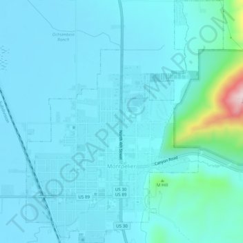
Name: Montpelier topographic map, elevation, terrain.
Location: Montpelier, Bear Lake County, Idaho, 83254, United States (42.31077 -111.31681 42.34663 -111.27736)
Average elevation: 6,043 ft
Minimum elevation: 5,925 ft
Maximum elevation: 7,054 ft
Bear Lake County trails, hiking, mountain biking, running and outdoor activities
Make a donation
Gear up for your next adventure:
As an Amazon Associate, this site earns from qualifying purchases at no extra cost to you.
Other topographic maps
Click on a map to view its topography, its elevation and its terrain.