
Make a donation
Gear up for your next adventure:
As an Amazon Associate, this site earns from qualifying purchases at no extra cost to you.
Bern topographic map
Click on the map to display elevation.
Make a donation
Gear up for your next adventure:
As an Amazon Associate, this site earns from qualifying purchases at no extra cost to you.
About this map
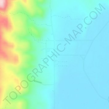
Name: Bern topographic map, elevation, terrain.
Location: Bern, Bear Lake County, Idaho, 83220, United States (42.32965 -111.39604 42.34965 -111.37604)
Average elevation: 6,096 ft
Minimum elevation: 5,919 ft
Maximum elevation: 6,791 ft
Bear Lake County trails, hiking, mountain biking, running and outdoor activities
Make a donation
Gear up for your next adventure:
As an Amazon Associate, this site earns from qualifying purchases at no extra cost to you.
Other topographic maps
Click on a map to view its topography, its elevation and its terrain.
St. Charles
United States > Idaho > Bear Lake County
St. Charles is located at 42°6′45″N 111°23′24″W / 42.11250°N 111.39000°W / 42.11250; -111.39000 (42.112493, -111.390001), at an elevation of 5,965 feet (1,818 m) above sea level.
Average elevation: 6,004 ft
Paris
United States > Idaho > Bear Lake County
Paris lies in a high valley of the Rocky Mountains, at nearly 6,000 feet (1,830 m) in elevation.
Average elevation: 6,007 ft
Make a donation
Gear up for your next adventure:
As an Amazon Associate, this site earns from qualifying purchases at no extra cost to you.
Montpelier
United States > Idaho > Bear Lake County
Montpelier is located at 42°19′13″N 111°18′13″W / 42.32028°N 111.30361°W / 42.32028; -111.30361 (42.320416, -111.303703), at an elevation of 5,981 feet (1,823 m) above sea level.
Average elevation: 6,043 ft