
龙南市 topographic map
Interactive map
Click on the map to display elevation.
About this map
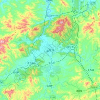
Name: 龙南市 topographic map, elevation, terrain.
Location: 龙南市, 赣州市, 江西省, 中国 (24.74466 114.63978 25.06466 114.95978)
Average elevation: 1,207 ft
Minimum elevation: 597 ft
Maximum elevation: 3,169 ft
Other topographic maps
Click on a map to view its topography, its elevation and its terrain.