
九连山镇 topographic map
Interactive map
Click on the map to display elevation.
About this map
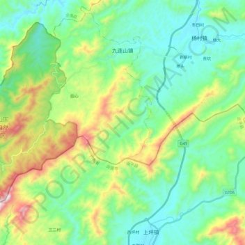
Name: 九连山镇 topographic map, elevation, terrain.
Location: 九连山镇, 龙南市, 赣州市, 江西省, 中国 (24.48885 114.38199 24.65599 114.58782)
Average elevation: 1,854 ft
Minimum elevation: 951 ft
Maximum elevation: 4,252 ft
Other topographic maps
Click on a map to view its topography, its elevation and its terrain.