
Thunder Bay topographic map
Click on the map to display elevation.
About this map
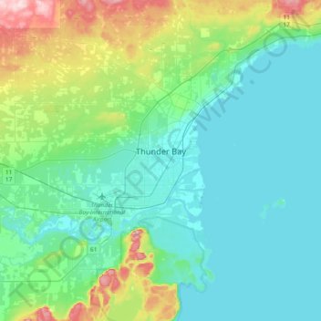
Name: Thunder Bay topographic map, elevation, terrain.
Average elevation: 787 ft
Minimum elevation: 577 ft
Maximum elevation: 1,617 ft
Other topographic maps
Click on a map to view its topography, its elevation and its terrain.
Upsala
Canada > Ontario > Thunder Bay District > Unorganized Thunder Bay District
Average elevation: 1,598 ft
Ara Lake
Canada > Ontario > Thunder Bay District > Unorganized Thunder Bay District
Average elevation: 1,010 ft
Springpole Island
Canada > Ontario > Thunder Bay District > Unorganized Thunder Bay District
Average elevation: 948 ft
Collins
Canada > Ontario > Thunder Bay District > Unorganized Thunder Bay District
Average elevation: 1,266 ft
Whitefish Lake
Canada > Ontario > Thunder Bay District > Unorganized Thunder Bay District
Average elevation: 1,549 ft
Sunbow Lake
Canada > Ontario > Thunder Bay District > Unorganized Thunder Bay District
Average elevation: 1,611 ft
Sulphur Lake
Canada > Ontario > Thunder Bay District > Unorganized Thunder Bay District
Average elevation: 1,532 ft
Tower Mountain
Canada > Ontario > Thunder Bay District > Unorganized Thunder Bay District
Average elevation: 1,886 ft
Trowbridge Island
Canada > Ontario > Thunder Bay District > Unorganized Thunder Bay District
Average elevation: 587 ft
Joyce Lake
Canada > Ontario > Thunder Bay District > Unorganized Thunder Bay District
Average elevation: 1,283 ft
Manitouwadge
Canada > Ontario > Thunder Bay District > Manitouwadge Township > Manitouwadge
Average elevation: 1,184 ft
Shebandowan
Canada > Ontario > Thunder Bay District > Unorganized Thunder Bay District
Average elevation: 1,512 ft
Nolalu
Canada > Ontario > Thunder Bay District > Unorganized Thunder Bay District
Average elevation: 1,214 ft
Livermore Lake
Canada > Ontario > Thunder Bay District > Unorganized Thunder Bay District
Average elevation: 1,499 ft
Tomlinson Lake
Canada > Ontario > Thunder Bay District > Unorganized Thunder Bay District
Average elevation: 1,604 ft
Sunshine
Canada > Ontario > Thunder Bay District > Unorganized Thunder Bay District
Average elevation: 1,316 ft
Papineau Lake;Wapoose Creek
Canada > Ontario > Thunder Bay District > Greenstone
Average elevation: 1,138 ft
Paint Lake
Canada > Ontario > Thunder Bay District > Unorganized Thunder Bay District
Average elevation: 1,476 ft
O'Brien Lake
Canada > Ontario > Thunder Bay District > Unorganized Thunder Bay District
Average elevation: 673 ft
Timmus Lake
Canada > Ontario > Thunder Bay District > Unorganized Thunder Bay District
Average elevation: 1,512 ft
Shabaqua Corners
Canada > Ontario > Thunder Bay District > Unorganized Thunder Bay District
Average elevation: 1,365 ft
Rossport
Canada > Ontario > Thunder Bay District > Unorganized Thunder Bay District
Average elevation: 745 ft
Cash Creek
Canada > Ontario > Thunder Bay District > Unorganized Thunder Bay District
Average elevation: 725 ft
Squash Lake
Canada > Ontario > Thunder Bay District > Unorganized Thunder Bay District
Average elevation: 1,142 ft
Cola Creek
Canada > Ontario > Thunder Bay District > Unorganized Thunder Bay District
Average elevation: 1,572 ft
Rossport
Canada > Ontario > Thunder Bay District > Unorganized Thunder Bay District
Average elevation: 745 ft
Topaz Lake
Canada > Ontario > Thunder Bay District > Unorganized Thunder Bay District
Average elevation: 1,581 ft
Manitouwadge
Canada > Ontario > Thunder Bay District > Manitouwadge Township
Average elevation: 1,184 ft