
Ara Lake topographic map
Click on the map to display elevation.
About this map
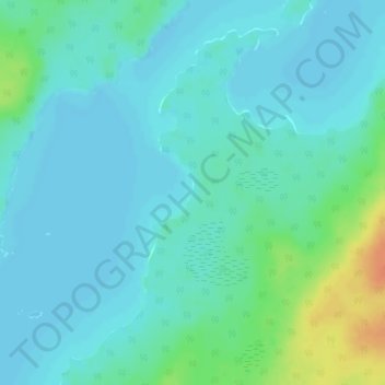
Name: Ara Lake topographic map, elevation, terrain.
Average elevation: 1,010 ft
Minimum elevation: 984 ft
Maximum elevation: 1,112 ft
Other topographic maps
Click on a map to view its topography, its elevation and its terrain.
Collins
Canada > Ontario > Thunder Bay District > Unorganized Thunder Bay District
Average elevation: 1,266 ft
Upsala
Canada > Ontario > Thunder Bay District > Unorganized Thunder Bay District
Average elevation: 1,598 ft
Nolalu
Canada > Ontario > Thunder Bay District > Unorganized Thunder Bay District
Average elevation: 1,214 ft
Lac des Mille Lacs
Canada > Ontario > Thunder Bay District > Unorganized Thunder Bay District
Average elevation: 1,539 ft
Tower Mountain
Canada > Ontario > Thunder Bay District > Unorganized Thunder Bay District
Average elevation: 1,886 ft
Lower Ross Lake
Canada > Ontario > Thunder Bay District > Unorganized Thunder Bay District
Average elevation: 1,289 ft
Quint Island Lake;Shacabac Creek
Canada > Ontario > Thunder Bay District > Unorganized Thunder Bay District
Average elevation: 928 ft
Whitefish Lake
Canada > Ontario > Thunder Bay District > Unorganized Thunder Bay District > Suomi
Average elevation: 1,496 ft
Shebandowan
Canada > Ontario > Thunder Bay District > Unorganized Thunder Bay District
Average elevation: 1,512 ft
Burness Lake
Canada > Ontario > Thunder Bay District > Unorganized Thunder Bay District
Average elevation: 988 ft
North Lake
Canada > Ontario > Thunder Bay District > Unorganized Thunder Bay District
Average elevation: 1,716 ft
Arrow Lake
Canada > Ontario > Thunder Bay District > Unorganized Thunder Bay District
Average elevation: 1,709 ft
Pass Lake
Canada > Ontario > Thunder Bay District > Unorganized Thunder Bay District
Average elevation: 850 ft
Miniss Lake
Canada > Ontario > Thunder Bay District > Unorganized Thunder Bay District
Average elevation: 1,293 ft
Sleeping Giant Provincial Park
Canada > Ontario > Thunder Bay District > Unorganized Thunder Bay District
Average elevation: 669 ft
Perute Lake
Canada > Ontario > Thunder Bay District > Unorganized Thunder Bay District
Average elevation: 1,345 ft
Harvey Lake
Canada > Ontario > Thunder Bay District > Unorganized Thunder Bay District
Average elevation: 974 ft
Wapikaimaski Lake
Canada > Ontario > Thunder Bay District > Unorganized Thunder Bay District
Average elevation: 1,434 ft
Sunshine
Canada > Ontario > Thunder Bay District > Unorganized Thunder Bay District
Average elevation: 1,316 ft
Horne Creek;Horne Lake
Canada > Ontario > Thunder Bay District > Unorganized Thunder Bay District
Average elevation: 1,453 ft
Ruffle Lake
Canada > Ontario > Thunder Bay District > Unorganized Thunder Bay District
Average elevation: 1,070 ft
Kapikotongwa River
Canada > Ontario > Thunder Bay District > Unorganized Thunder Bay District
Average elevation: 879 ft
DeCourcey Lake
Canada > Ontario > Thunder Bay District > Unorganized Thunder Bay District
Average elevation: 1,499 ft
Shabaqua Corners
Canada > Ontario > Thunder Bay District > Unorganized Thunder Bay District
Average elevation: 1,365 ft
Rossport
Canada > Ontario > Thunder Bay District > Unorganized Thunder Bay District
Average elevation: 745 ft
Springpole Island
Canada > Ontario > Thunder Bay District > Unorganized Thunder Bay District
Average elevation: 948 ft
Hicks Lake
Canada > Ontario > Thunder Bay District > Unorganized Thunder Bay District
Average elevation: 1,552 ft
Whitesand Lake
Canada > Ontario > Thunder Bay District > Unorganized Thunder Bay District
Average elevation: 1,043 ft
Wapikaimaski Lake
Canada > Ontario > Thunder Bay District > Unorganized Thunder Bay District
Average elevation: 1,434 ft
Rossport
Canada > Ontario > Thunder Bay District > Unorganized Thunder Bay District
Average elevation: 745 ft
Georgia Lake
Canada > Ontario > Thunder Bay District > Unorganized Thunder Bay District
Average elevation: 1,506 ft
Sleeping Giant Provincial Park
Canada > Ontario > Thunder Bay District > Unorganized Thunder Bay District
Average elevation: 669 ft
District Lake
Canada > Ontario > Thunder Bay District > Unorganized Thunder Bay District
Average elevation: 1,578 ft