
Sunshine topographic map
Click on the map to display elevation.
About this map
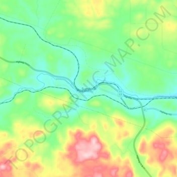
Name: Sunshine topographic map, elevation, terrain.
Average elevation: 1,316 ft
Minimum elevation: 1,043 ft
Maximum elevation: 1,804 ft
Other topographic maps
Click on a map to view its topography, its elevation and its terrain.
Lac des Mille Lacs
Canada > Ontario > Thunder Bay District > Unorganized Thunder Bay District
Average elevation: 1,539 ft
Tomlinson Lake
Canada > Ontario > Thunder Bay District > Unorganized Thunder Bay District
Average elevation: 1,604 ft
Whitefish Lake
Canada > Ontario > Thunder Bay District > Unorganized Thunder Bay District
Average elevation: 1,549 ft
North Lake
Canada > Ontario > Thunder Bay District > Unorganized Thunder Bay District
Average elevation: 1,716 ft
Sunbow Lake
Canada > Ontario > Thunder Bay District > Unorganized Thunder Bay District
Average elevation: 1,611 ft
Sulphur Lake
Canada > Ontario > Thunder Bay District > Unorganized Thunder Bay District
Average elevation: 1,532 ft
Trowbridge Island
Canada > Ontario > Thunder Bay District > Unorganized Thunder Bay District
Average elevation: 587 ft
Lower Ross Lake
Canada > Ontario > Thunder Bay District > Unorganized Thunder Bay District
Average elevation: 1,289 ft
Joyce Lake
Canada > Ontario > Thunder Bay District > Unorganized Thunder Bay District
Average elevation: 1,283 ft
Quint Island Lake;Shacabac Creek
Canada > Ontario > Thunder Bay District > Unorganized Thunder Bay District
Average elevation: 928 ft
Whitefish Lake
Canada > Ontario > Thunder Bay District > Unorganized Thunder Bay District > Suomi
Average elevation: 1,496 ft
Burness Lake
Canada > Ontario > Thunder Bay District > Unorganized Thunder Bay District
Average elevation: 988 ft
Arrow Lake
Canada > Ontario > Thunder Bay District > Unorganized Thunder Bay District
Average elevation: 1,709 ft
Pass Lake
Canada > Ontario > Thunder Bay District > Unorganized Thunder Bay District
Average elevation: 850 ft
Miniss Lake
Canada > Ontario > Thunder Bay District > Unorganized Thunder Bay District
Average elevation: 1,293 ft
Sleeping Giant Provincial Park
Canada > Ontario > Thunder Bay District > Unorganized Thunder Bay District
Average elevation: 669 ft
Perute Lake
Canada > Ontario > Thunder Bay District > Unorganized Thunder Bay District
Average elevation: 1,345 ft
Harvey Lake
Canada > Ontario > Thunder Bay District > Unorganized Thunder Bay District
Average elevation: 974 ft
Wapikaimaski Lake
Canada > Ontario > Thunder Bay District > Unorganized Thunder Bay District
Average elevation: 1,434 ft
Horne Creek;Horne Lake
Canada > Ontario > Thunder Bay District > Unorganized Thunder Bay District
Average elevation: 1,453 ft
Ruffle Lake
Canada > Ontario > Thunder Bay District > Unorganized Thunder Bay District
Average elevation: 1,070 ft
Ara Lake
Canada > Ontario > Thunder Bay District > Unorganized Thunder Bay District
Average elevation: 1,010 ft
Paint Lake
Canada > Ontario > Thunder Bay District > Unorganized Thunder Bay District
Average elevation: 1,476 ft
O'Brien Lake
Canada > Ontario > Thunder Bay District > Unorganized Thunder Bay District
Average elevation: 673 ft
Kapikotongwa River
Canada > Ontario > Thunder Bay District > Unorganized Thunder Bay District
Average elevation: 879 ft
Timmus Lake
Canada > Ontario > Thunder Bay District > Unorganized Thunder Bay District
Average elevation: 1,512 ft
DeCourcey Lake
Canada > Ontario > Thunder Bay District > Unorganized Thunder Bay District
Average elevation: 1,499 ft
Cash Creek
Canada > Ontario > Thunder Bay District > Unorganized Thunder Bay District
Average elevation: 725 ft
Wapikaimaski Lake
Canada > Ontario > Thunder Bay District > Unorganized Thunder Bay District
Average elevation: 1,434 ft
Whitesand Lake
Canada > Ontario > Thunder Bay District > Unorganized Thunder Bay District
Average elevation: 1,043 ft
Livermore Lake
Canada > Ontario > Thunder Bay District > Unorganized Thunder Bay District
Average elevation: 1,499 ft
Squash Lake
Canada > Ontario > Thunder Bay District > Unorganized Thunder Bay District
Average elevation: 1,142 ft
Cola Creek
Canada > Ontario > Thunder Bay District > Unorganized Thunder Bay District
Average elevation: 1,572 ft
Georgia Lake
Canada > Ontario > Thunder Bay District > Unorganized Thunder Bay District
Average elevation: 1,506 ft
Sleeping Giant Provincial Park
Canada > Ontario > Thunder Bay District > Unorganized Thunder Bay District
Average elevation: 669 ft
Topaz Lake
Canada > Ontario > Thunder Bay District > Unorganized Thunder Bay District
Average elevation: 1,581 ft
District Lake
Canada > Ontario > Thunder Bay District > Unorganized Thunder Bay District
Average elevation: 1,578 ft