
Millstone topographic map
Click on the map to display elevation.
About this map
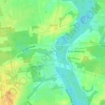
Name: Millstone topographic map, elevation, terrain.
Location: Millstone, Somerset County, New Jersey, United States (40.49305 -74.60271 40.50937 -74.57715)
Average elevation: 72 ft
Minimum elevation: 23 ft
Maximum elevation: 135 ft
Somerset County trails, hiking, mountain biking, running and outdoor activities
Other topographic maps
Click on a map to view its topography, its elevation and its terrain.
Blackwells Mills
United States > New Jersey > Somerset County > Franklin Township
Average elevation: 79 ft
Bradley Gardens
United States > New Jersey > Somerset County > Bridgewater Township
Average elevation: 92 ft
Franklin Park Natural Area
United States > New Jersey > Somerset County > Franklin Township
Average elevation: 131 ft
Green Knoll
United States > New Jersey > Somerset County > Bridgewater Township
Average elevation: 207 ft
Grandview
United States > New Jersey > Somerset County > Bridgewater Township
Average elevation: 184 ft
Dutchtown
United States > New Jersey > Somerset County > Montgomery Township
Average elevation: 161 ft
Green Brook
United States > New Jersey > Somerset County > Green Brook Township
Average elevation: 141 ft
Second Watchung Mountain
United States > New Jersey > Somerset County > Bridgewater Township
Average elevation: 361 ft
First Watchung Mountain
United States > New Jersey > Somerset County > Bridgewater Township
Average elevation: 180 ft