Geolocate

Cheohee topographic map

Click on the map to display elevation.

About this map

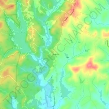
Name: Cheohee topographic map, elevation, terrain.

Location: Cheohee, Oconee County, South Carolina, 29686, United States (34.88231 -83.06765 34.92231 -83.02765)

Average elevation: 1,112 ft

Minimum elevation: 1,010 ft

Maximum elevation: 1,266 ft

Oconee County trails, hiking, mountain biking, running and outdoor activities

Other topographic maps

Click on a map to view its topography, its elevation and its terrain.

Seneca

United States > South Carolina > Oconee County

Average elevation: 869 ft

Lake Keowee

United States > South Carolina > Oconee County > Seneca

Average elevation: 958 ft

Walhalla

United States > South Carolina > Oconee County

Average elevation: 971 ft

Salem

United States > South Carolina > Oconee County

Average elevation: 1,037 ft

Westminster

United States > South Carolina > Oconee County

Average elevation: 892 ft

West Union

United States > South Carolina > Oconee County

Average elevation: 948 ft

Seneca

United States > South Carolina > Oconee County

Average elevation: 869 ft

Seneca

United States > South Carolina > Oconee County

Average elevation: 869 ft

Salem

United States > South Carolina > Oconee County

Average elevation: 1,037 ft

Gear up for your next adventure:

🧣Merino Neck Gaiters - Multi-functional headwear for wind and sun protection
🪑Portable Camp Table - Compact table for campsite meals
🦺Reflective Outdoor Gear - Safety gear for low‑light conditions
🩳Quick‑Dry Hiking Shorts - Comfortable and quick‑dry shorts for summer hiking
🚪Portable Camp Chair - Foldable chair for comfort at camp

As an Amazon Associate, this site earns from qualifying purchases at no extra cost to you.