Geolocate

Westminster topographic map

Click on the map to display elevation.

About this map

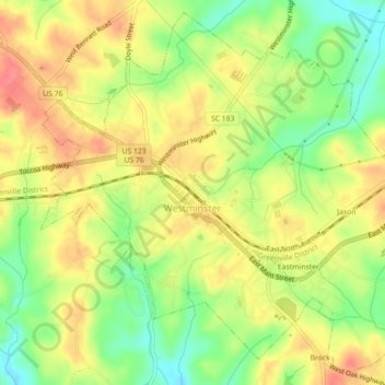
Name: Westminster topographic map, elevation, terrain.

Location: Westminster, Oconee County, South Carolina, United States (34.64914 -83.11404 34.68337 -83.06973)

Average elevation: 892 ft

Minimum elevation: 771 ft

Maximum elevation: 997 ft

Oconee County trails, hiking, mountain biking, running and outdoor activities

Other topographic maps

Click on a map to view its topography, its elevation and its terrain.

Wexford

United States > South Carolina > Oconee County

Average elevation: 761 ft

Cheohee

United States > South Carolina > Oconee County

Average elevation: 1,112 ft

Madison

United States > South Carolina > Oconee County

Average elevation: 787 ft

Mountain Rest

United States > South Carolina > Oconee County

Average elevation: 1,703 ft

Phinney

United States > South Carolina > Oconee County

Average elevation: 886 ft

Jason

United States > South Carolina > Oconee County > Westminster

Average elevation: 883 ft

Mountain Rest

United States > South Carolina > Oconee County

Average elevation: 1,703 ft

Dalton

United States > South Carolina > Oconee County > Seneca

Average elevation: 876 ft

Long Creek

United States > South Carolina > Oconee County

Average elevation: 1,572 ft

Gear up for your next adventure:

🛡️Insect Repellent - Protection against bugs during outdoor activities
😴Insulated Sleeping Pads - Compact and warm pads for high-elevation camping
🚪Portable Camp Chair - Foldable chair for comfort at camp
👖Convertible Hiking Pants - Versatile zip-off pants for changing altitudes and temperatures
🧴Hand Sanitizer - Keep hands clean while hiking

As an Amazon Associate, this site earns from qualifying purchases at no extra cost to you.