Geolocate

Seneca topographic map

Click on the map to display elevation.

About this map

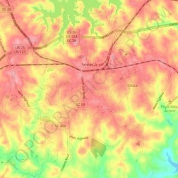
Name: Seneca topographic map, elevation, terrain.

Location: Seneca, Oconee County, South Carolina, United States (34.64130 -82.99495 34.71206 -82.92834)

Average elevation: 869 ft

Minimum elevation: 656 ft

Maximum elevation: 988 ft

Oconee County trails, hiking, mountain biking, running and outdoor activities

Other topographic maps

Click on a map to view its topography, its elevation and its terrain.

Madison

United States > South Carolina > Oconee County

Average elevation: 787 ft

Cheohee

United States > South Carolina > Oconee County

Average elevation: 1,112 ft

Phinney

United States > South Carolina > Oconee County

Average elevation: 886 ft

Mountain Rest

United States > South Carolina > Oconee County

Average elevation: 1,703 ft

Wexford

United States > South Carolina > Oconee County

Average elevation: 761 ft

Jason

United States > South Carolina > Oconee County > Westminster

Average elevation: 883 ft

Long Creek

United States > South Carolina > Oconee County

Average elevation: 1,572 ft

Mountain Rest

United States > South Carolina > Oconee County

Average elevation: 1,703 ft

Dalton

United States > South Carolina > Oconee County > Seneca

Average elevation: 876 ft

Gear up for your next adventure:

🛠️Backpacking Tool Kit - Essential toolkit for outdoor repairs
🪶Survival Guide Book - Expert advice for emergency preparedness
🧴Hand Sanitizer - Keep hands clean while hiking
🪶Wildlife Field Guides - Learn animal tracking and species ID
🛠️Outdoor Gear Repair Kit - Essential tools to fix gear on the trail

As an Amazon Associate, this site earns from qualifying purchases at no extra cost to you.