
Make a donation
Gear up for your next adventure:
As an Amazon Associate, this site earns from qualifying purchases at no extra cost to you.
Upper Austria topographic map
Click on the map to display elevation.
Make a donation
Gear up for your next adventure:
As an Amazon Associate, this site earns from qualifying purchases at no extra cost to you.
About this map
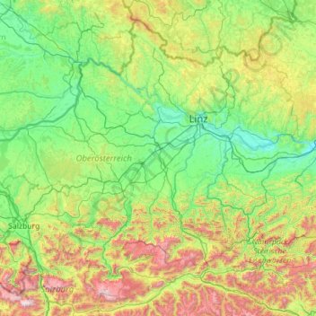
Name: Upper Austria topographic map, elevation, terrain.
Location: Upper Austria, Austria (47.46111 12.74924 48.77256 14.99217)
Average elevation: 2,369 ft
Minimum elevation: 712 ft
Maximum elevation: 9,439 ft
Make a donation
Gear up for your next adventure:
As an Amazon Associate, this site earns from qualifying purchases at no extra cost to you.
Other topographic maps
Click on a map to view its topography, its elevation and its terrain.
Lahnberg
Austria > Lower Austria > Bezirk Neunkirchen > Schwarzau im Gebirge
Average elevation: 3,980 ft
Make a donation
Gear up for your next adventure:
As an Amazon Associate, this site earns from qualifying purchases at no extra cost to you.
Klagenfurt Land
Austria > Carinthia > Bezirk Klagenfurt-Land > Krumpendorf am Wörthersee
Average elevation: 2,933 ft
Bad Eisenkappel/Železna Kapla
Austria > Carinthia > Bezirk Völkermarkt > Eisenkappel-Vellach
Average elevation: 2,999 ft
Make a donation
Gear up for your next adventure:
As an Amazon Associate, this site earns from qualifying purchases at no extra cost to you.
Make a donation
Gear up for your next adventure:
As an Amazon Associate, this site earns from qualifying purchases at no extra cost to you.