
Make a donation
Gear up for your next adventure:
As an Amazon Associate, this site earns from qualifying purchases at no extra cost to you.
Great Gidding topographic map
Click on the map to display elevation.
Make a donation
Gear up for your next adventure:
As an Amazon Associate, this site earns from qualifying purchases at no extra cost to you.
About this map
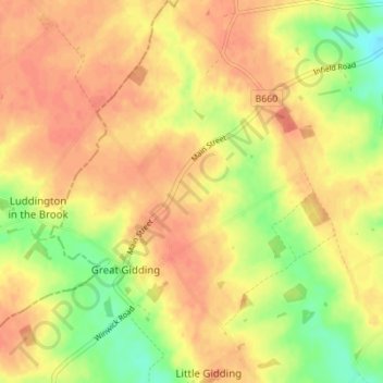
Name: Great Gidding topographic map, elevation, terrain.
Average elevation: 187 ft
Minimum elevation: 95 ft
Maximum elevation: 233 ft
Make a donation
Gear up for your next adventure:
As an Amazon Associate, this site earns from qualifying purchases at no extra cost to you.
Other topographic maps
Click on a map to view its topography, its elevation and its terrain.
Green End
United Kingdom > England > Cambridgeshire > Huntingdonshire > Great Stukeley
Average elevation: 105 ft
Hinchingbrooke Country Park
United Kingdom > England > Cambridgeshire > Huntingdonshire > Huntingdon > Brampton
Average elevation: 52 ft
Make a donation
Gear up for your next adventure:
As an Amazon Associate, this site earns from qualifying purchases at no extra cost to you.
Huntingdon Castle
United Kingdom > England > Cambridgeshire > Huntingdonshire > Huntingdon > Hartford
Average elevation: 46 ft
Make a donation
Gear up for your next adventure:
As an Amazon Associate, this site earns from qualifying purchases at no extra cost to you.
Make a donation
Gear up for your next adventure:
As an Amazon Associate, this site earns from qualifying purchases at no extra cost to you.
Washingley
United Kingdom > England > Cambridgeshire > Huntingdonshire > Folksworth
Average elevation: 157 ft
Make a donation
Gear up for your next adventure:
As an Amazon Associate, this site earns from qualifying purchases at no extra cost to you.
Make a donation
Gear up for your next adventure:
As an Amazon Associate, this site earns from qualifying purchases at no extra cost to you.
Hartford Marina
United Kingdom > England > Cambridgeshire > Huntingdonshire > Wyton
Average elevation: 46 ft
Holywell
United Kingdom > England > Cambridgeshire > Huntingdonshire > Holywell
Average elevation: 23 ft
Make a donation
Gear up for your next adventure:
As an Amazon Associate, this site earns from qualifying purchases at no extra cost to you.
Leighton Bromswold
United Kingdom > England > Cambridgeshire > Huntingdonshire
Average elevation: 161 ft
Keyston
United Kingdom > England > Cambridgeshire > Huntingdonshire > Keyston
Average elevation: 203 ft
Make a donation
Gear up for your next adventure:
As an Amazon Associate, this site earns from qualifying purchases at no extra cost to you.
Mill Pool
United Kingdom > England > Cambridgeshire > Huntingdonshire > Huntingdon
Average elevation: 46 ft
Make a donation
Gear up for your next adventure:
As an Amazon Associate, this site earns from qualifying purchases at no extra cost to you.