
Brington topographic map
Click on the map to display elevation.
About this map
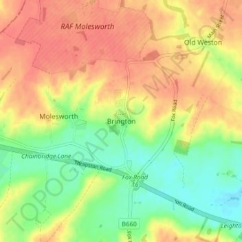
Name: Brington topographic map, elevation, terrain.
Average elevation: 184 ft
Minimum elevation: 89 ft
Maximum elevation: 259 ft
Other topographic maps
Click on a map to view its topography, its elevation and its terrain.
Brampton
United Kingdom > England > Cambridgeshire > Huntingdonshire > Brampton
Average elevation: 72 ft
Hinchingbrooke Country Park
United Kingdom > England > Cambridgeshire > Huntingdonshire > Huntingdon > Brampton
Average elevation: 52 ft
Kimbolton
United Kingdom > England > Cambridgeshire > Huntingdonshire > Kimbolton
Average elevation: 177 ft
Bluntisham
United Kingdom > England > Cambridgeshire > Huntingdonshire > Bluntisham
Average elevation: 39 ft
Grafham
United Kingdom > England > Cambridgeshire > Huntingdonshire > Grafham
Average elevation: 148 ft
Kings Ripton
United Kingdom > England > Cambridgeshire > Huntingdonshire > Kings Ripton
Average elevation: 112 ft
Catworth
United Kingdom > England > Cambridgeshire > Huntingdonshire > Catworth
Average elevation: 177 ft
Old Weston
United Kingdom > England > Cambridgeshire > Huntingdonshire > Old Weston
Average elevation: 213 ft
Great Staughton
United Kingdom > England > Cambridgeshire > Huntingdonshire > Great Staughton
Average elevation: 141 ft
Holywell-cum-Needingworth
United Kingdom > England > Cambridgeshire > Huntingdonshire
Average elevation: 33 ft
Hail Weston
United Kingdom > England > Cambridgeshire > Huntingdonshire > Hail Weston
Average elevation: 102 ft
Alconbury Weston
United Kingdom > England > Cambridgeshire > Huntingdonshire
Average elevation: 105 ft
Hemingford Grey
United Kingdom > England > Cambridgeshire > Huntingdonshire > Hemingford Grey
Average elevation: 36 ft
Abbots Ripton
United Kingdom > England > Cambridgeshire > Huntingdonshire > Abbots Ripton
Average elevation: 125 ft
Broughton
United Kingdom > England > Cambridgeshire > Huntingdonshire > Broughton
Average elevation: 102 ft
Woodhurst
United Kingdom > England > Cambridgeshire > Huntingdonshire > Woodhurst
Average elevation: 102 ft
Hartford Marina
United Kingdom > England > Cambridgeshire > Huntingdonshire > Wyton
Average elevation: 46 ft
Mill Pool
United Kingdom > England > Cambridgeshire > Huntingdonshire > Huntingdon
Average elevation: 46 ft
Offord Cluny and Offord D'Arcy
United Kingdom > England > Cambridgeshire > Huntingdonshire > Offord Darcy
Average elevation: 102 ft
Bluntisham
United Kingdom > England > Cambridgeshire > Huntingdonshire > Bluntisham
Average elevation: 39 ft
Yelling
United Kingdom > England > Cambridgeshire > Huntingdonshire > Yelling
Average elevation: 177 ft
Kimbolton
United Kingdom > England > Cambridgeshire > Huntingdonshire > Kimbolton
Average elevation: 177 ft