Geolocate

Alpena topographic map

Click on the map to display elevation.

About this map

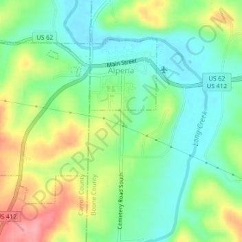
Name: Alpena topographic map, elevation, terrain.

Location: Alpena, Boone County, Arkansas, 72611, United States (36.27875 -93.31566 36.29712 -93.28836)

Average elevation: 1,224 ft

Minimum elevation: 1,096 ft

Maximum elevation: 1,434 ft

Boone County trails, hiking, mountain biking, running and outdoor activities

Other topographic maps

Click on a map to view its topography, its elevation and its terrain.

Little Arkansaw

United States > Arkansas > Boone County

Average elevation: 1,427 ft

Olvey

United States > Arkansas > Boone County

Average elevation: 1,109 ft

Batavia

United States > Arkansas > Boone County

Average elevation: 1,493 ft

Capps

United States > Arkansas > Boone County

Average elevation: 1,424 ft

Lead Hill

United States > Arkansas > Boone County

Average elevation: 1,004 ft

Gear up for your next adventure:

Camping Coffee Makers - Enjoy premium coffee at the summit or campsite
🔭Telescopic Hiking Pole - Adjustable pole for hiking stability
📖Nature Tracking Books - Learn to track wildlife and terrain
🏥Hiking First Aid Kits - Comprehensive medical kits for remote trail injuries
🦶Hiking Gaiters - Keep debris and water out of your boots

As an Amazon Associate, this site earns from qualifying purchases at no extra cost to you.