Geolocate

Batavia topographic map

Click on the map to display elevation.

About this map

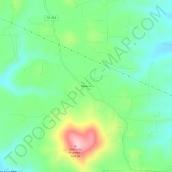
Name: Batavia topographic map, elevation, terrain.

Location: Batavia, Boone County, Arkansas, United States (36.23507 -93.24268 36.27507 -93.20268)

Average elevation: 1,493 ft

Minimum elevation: 1,247 ft

Maximum elevation: 2,028 ft

Boone County trails, hiking, mountain biking, running and outdoor activities

Other topographic maps

Click on a map to view its topography, its elevation and its terrain.

South Lead Hill

United States > Arkansas > Boone County

Average elevation: 797 ft

Valley Springs

United States > Arkansas > Boone County

Average elevation: 1,132 ft

Zinc

United States > Arkansas > Boone County

Zinc is in the Ozark region and has an elevation of 879 feet (268 m).

Average elevation: 1,063 ft

Diamond City

United States > Arkansas > Boone County

Average elevation: 732 ft

Everton

United States > Arkansas > Boone County

Average elevation: 958 ft

Alpena

United States > Arkansas > Boone County

Average elevation: 1,224 ft

Gear up for your next adventure:

🧯Emergency Survival Kit - All‑in‑one survival essentials for the backcountry
🧯Portable Fire Pit - Compact fire pit for camping spots
Solar GPS Watches - Advanced multisport watches with built-in topographic maps
🦶Carbon Trekking Poles - Reduce knee impact on steep descents with ultra-light poles
📶Vehicle Signal Boosters - Improve reception in rural areas while driving to trailheads

As an Amazon Associate, this site earns from qualifying purchases at no extra cost to you.