
Make a donation
Gear up for your next adventure:
As an Amazon Associate, this site earns from qualifying purchases at no extra cost to you.
Lead Hill topographic map
Click on the map to display elevation.
Make a donation
Gear up for your next adventure:
As an Amazon Associate, this site earns from qualifying purchases at no extra cost to you.
About this map
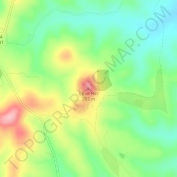
Name: Lead Hill topographic map, elevation, terrain.
Location: Lead Hill, Boone County, Arkansas, United States (36.43196 -93.01439 36.43206 -93.01429)
Average elevation: 1,004 ft
Minimum elevation: 807 ft
Maximum elevation: 1,299 ft
Boone County trails, hiking, mountain biking, running and outdoor activities
Make a donation
Gear up for your next adventure:
As an Amazon Associate, this site earns from qualifying purchases at no extra cost to you.
Other topographic maps
Click on a map to view its topography, its elevation and its terrain.
Zinc
United States > Arkansas > Boone County
Zinc is in the Ozark region and has an elevation of 879 feet (268 m).
Average elevation: 1,063 ft
Make a donation
Gear up for your next adventure:
As an Amazon Associate, this site earns from qualifying purchases at no extra cost to you.