
Make a donation
Gear up for your next adventure:
As an Amazon Associate, this site earns from qualifying purchases at no extra cost to you.
Lesslie topographic map
Click on the map to display elevation.
Make a donation
Gear up for your next adventure:
As an Amazon Associate, this site earns from qualifying purchases at no extra cost to you.
Lesslie
Lesslie has a total area of 6.0 square miles (16 km2), and an elevation of 701 feet (214 m).
Make a donation
Gear up for your next adventure:
As an Amazon Associate, this site earns from qualifying purchases at no extra cost to you.
About this map
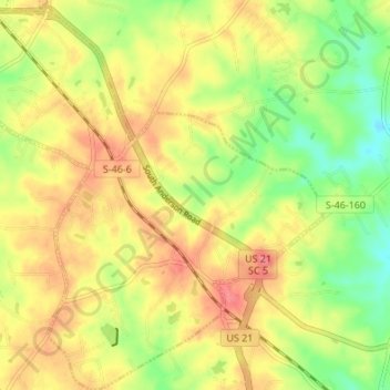
Name: Lesslie topographic map, elevation, terrain.
Location: Lesslie, York County, South Carolina, United States (34.85779 -80.98677 34.91337 -80.92019)
Average elevation: 633 ft
Minimum elevation: 509 ft
Maximum elevation: 741 ft
York County trails, hiking, mountain biking, running and outdoor activities
Make a donation
Gear up for your next adventure:
As an Amazon Associate, this site earns from qualifying purchases at no extra cost to you.
Other topographic maps
Click on a map to view its topography, its elevation and its terrain.
Make a donation
Gear up for your next adventure:
As an Amazon Associate, this site earns from qualifying purchases at no extra cost to you.
Make a donation
Gear up for your next adventure:
As an Amazon Associate, this site earns from qualifying purchases at no extra cost to you.
Rock Hill
United States > South Carolina > York County > Rock Hill > Rock Hill
Average elevation: 607 ft
Make a donation
Gear up for your next adventure:
As an Amazon Associate, this site earns from qualifying purchases at no extra cost to you.
Old Orchid
United States > South Carolina > York County > Fort Mill > Old Orchid
Average elevation: 604 ft