Geolocate

Pantai topographic map

Click on the map to display elevation.

About this map

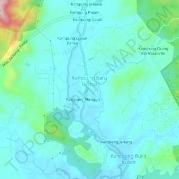
Name: Pantai topographic map, elevation, terrain.

Location: Pantai, Seremban, Negeri Sembilan, 71770, Malaysia (2.76152 101.97316 2.80152 102.01316)

Average elevation: 358 ft

Minimum elevation: 210 ft

Maximum elevation: 1,079 ft

Other topographic maps

Click on a map to view its topography, its elevation and its terrain.

Rembau

Malaysia > Negeri Sembilan

Average elevation: 525 ft

Jelebu

Malaysia > Negeri Sembilan

Amongst the seven districts of Negeri Sembilan, Jelebu is the most mountainous topographically as the Titiwangsa Mountains, the longest mountain range in Malaysia, transverses through the district. As a result, most of its terrain are dominated by forested undulating hills and mountain peaks. The Titiwangsa…

Average elevation: 1,007 ft

Kuala Pilah

Malaysia > Negeri Sembilan

Average elevation: 794 ft

Muar River

Malaysia > Negeri Sembilan

Average elevation: 180 ft

Gear up for your next adventure:

🥩Freeze-Dried Meals - Nutritious and lightweight food for remote expeditions
🚑Emergency Bivvies - Heat-reflective sleeping bags for survival situations
🔦LED Headlamp - Bright and durable LED headlamp for night navigation
🎁Geography Themed Gifts - Unique gift ideas for map lovers and geography enthusiasts
🦶Carbon Trekking Poles - Reduce knee impact on steep descents with ultra-light poles

As an Amazon Associate, this site earns from qualifying purchases at no extra cost to you.