Geolocate

Jelebu topographic map

Click on the map to display elevation.

Jelebu

Amongst the seven districts of Negeri Sembilan, Jelebu is the most mountainous topographically as the Titiwangsa Mountains, the longest mountain range in Malaysia, transverses through the district. As a result, most of its terrain are dominated by forested undulating hills and mountain peaks. The Titiwangsa Mountains open up into a 77 sq km (30 sq mi) wide intermontane basin encompassing the central part of the district, of which major settlements like Kuala Klawang and Titi are situated in. The eastern and southern parts of the district are relatively flat, where agriculture flourished. Jelebu District is home to Negeri Sembilan's tallest mountain, Mount Besar Hantu (1,462 m), near the border with Pahang. The other significant peak within the district is Mount Telapak Buruk (1,193 m) on the border with Seremban District. The Pasoh Caves, the southernmost limestone cave complex in Malaysia, is also located in Jelebu. The Pasoh Caves are also known for being the first Paleolithic site in southern Peninsular Malaysia, as well as the southernmost in Malaysia.

Wikipedia (CC-BY-SA 3.0)

About this map

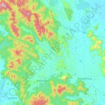
Name: Jelebu topographic map, elevation, terrain.

Location: Jelebu, Negeri Sembilan, Malaysia (2.82976 101.91385 3.29033 102.35321)

Average elevation: 1,007 ft

Minimum elevation: 115 ft

Maximum elevation: 4,708 ft

Other topographic maps

Click on a map to view its topography, its elevation and its terrain.

Gadong

Malaysia > Negeri Sembilan

Average elevation: 217 ft

Kampung Panchor

Malaysia > Negeri Sembilan

Average elevation: 404 ft

Gunung Datuk

Malaysia > Negeri Sembilan

The main highlight of the mountain is a tor that consists of massive granite boulders, at the elevation of 855 m (2,805 ft).

Average elevation: 1,493 ft

Port Dickson

Malaysia > Negeri Sembilan

Average elevation: 39 ft

Pantai

Malaysia > Negeri Sembilan

Average elevation: 358 ft

Bukit Kutu

Malaysia > Negeri Sembilan

Average elevation: 2,198 ft

Linggi

Malaysia > Negeri Sembilan

Average elevation: 72 ft

Kampung Ulu Bendul

Malaysia > Negeri Sembilan

Average elevation: 1,070 ft

Gemas

Malaysia > Negeri Sembilan > Gemas

Average elevation: 138 ft

Kampung Batu 10 Labu

Malaysia > Negeri Sembilan > Labu

Average elevation: 167 ft

Lenggeng

Malaysia > Negeri Sembilan

Average elevation: 482 ft

Tampin

Malaysia > Negeri Sembilan > Tampin

Average elevation: 397 ft

Gemencheh

Malaysia > Negeri Sembilan

Average elevation: 276 ft

Bukit Tering

Malaysia > Negeri Sembilan

Average elevation: 627 ft

Gear up for your next adventure:

🛰️Handheld GPS Units - Professional satellite navigators for precise backcountry mapping
🪶Trail Camera - Capture wildlife on your hikes
🗃️Trail First Aid Kit - Essential kit for outdoor injuries and emergencies
🔦LED Headlamp - Bright and durable LED headlamp for night navigation
🛡️Insect Repellent - Protection against bugs during outdoor activities

As an Amazon Associate, this site earns from qualifying purchases at no extra cost to you.