
Make a donation
Gear up for your next adventure:
As an Amazon Associate, this site earns from qualifying purchases at no extra cost to you.
Nungesser Lake topographic map
Click on the map to display elevation.
Make a donation
Gear up for your next adventure:
As an Amazon Associate, this site earns from qualifying purchases at no extra cost to you.
About this map
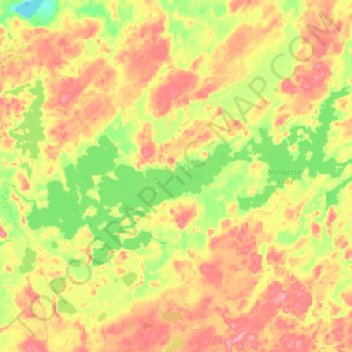
Name: Nungesser Lake topographic map, elevation, terrain.
Average elevation: 1,352 ft
Minimum elevation: 1,204 ft
Maximum elevation: 1,499 ft
Make a donation
Gear up for your next adventure:
As an Amazon Associate, this site earns from qualifying purchases at no extra cost to you.
Other topographic maps
Click on a map to view its topography, its elevation and its terrain.
Slate Islands
Canada > Ontario > Kenora District > Unorganized Kenora District
Average elevation: 1,056 ft
Galbraith Lake
Canada > Ontario > Kenora District > Unorganized Kenora District
Average elevation: 1,493 ft
Loveland Lake
Canada > Ontario > Kenora District > Unorganized Kenora District
Average elevation: 1,398 ft
Make a donation
Gear up for your next adventure:
As an Amazon Associate, this site earns from qualifying purchases at no extra cost to you.
Edison Lake
Canada > Ontario > Kenora District > Unorganized Kenora District
Average elevation: 1,263 ft
Banana Island
Canada > Ontario > Kenora District > Unorganized Kenora District
Average elevation: 1,178 ft
Ghost Island
Canada > Ontario > Kenora District > Unorganized Kenora District
Average elevation: 1,316 ft
Look Lake
Canada > Ontario > Kenora District > Unorganized Kenora District
Average elevation: 1,289 ft
Make a donation
Gear up for your next adventure:
As an Amazon Associate, this site earns from qualifying purchases at no extra cost to you.
Almo Lake
Canada > Ontario > Kenora District > Unorganized Kenora District
Average elevation: 1,201 ft
Cole Lake
Canada > Ontario > Kenora District > Unorganized Kenora District
Average elevation: 1,368 ft