
Town of Ballston topographic map
Interactive map
Click on the map to display elevation.
About this map
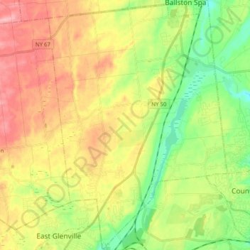
Name: Town of Ballston topographic map, elevation, terrain.
Location: Town of Ballston, Saratoga County, New York, United States (42.88788 -73.93446 43.00164 -73.82293)
Average elevation: 387 ft
Minimum elevation: 194 ft
Maximum elevation: 617 ft
Saratoga County trails, hiking, mountain biking, running and outdoor activities
Other topographic maps
Click on a map to view its topography, its elevation and its terrain.
Saratoga Springs
United States > New York > Saratoga County > Saratoga Springs
Average elevation: 528 ft
Vischer Ferry
United States > New York > Saratoga County > Town of Clifton Park
Average elevation: 243 ft
Halfmoon
United States > New York > Saratoga County > Halfmoon
Halfmoon is a town in Saratoga County, New York, United States. The population was 21,535 at the 2010 census. The town is apparently named for the shape of the lower elevation land north of the junction of the Hudson and Mohawk Rivers. It is also said to be named for Henry Hudson's ship.
Average elevation: 276 ft
Elnora
United States > New York > Saratoga County > Town of Clifton Park > Elnora
Average elevation: 322 ft