
Make a donation
Gear up for your next adventure:
As an Amazon Associate, this site earns from qualifying purchases at no extra cost to you.
Greenfield Center topographic map
Click on the map to display elevation.
Make a donation
Gear up for your next adventure:
As an Amazon Associate, this site earns from qualifying purchases at no extra cost to you.
About this map
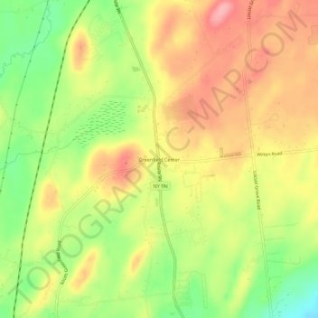
Name: Greenfield Center topographic map, elevation, terrain.
Average elevation: 669 ft
Minimum elevation: 466 ft
Maximum elevation: 837 ft
Saratoga County trails, hiking, mountain biking, running and outdoor activities
Make a donation
Gear up for your next adventure:
As an Amazon Associate, this site earns from qualifying purchases at no extra cost to you.
Other topographic maps
Click on a map to view its topography, its elevation and its terrain.
Town of Clifton Park
United States > New York > Saratoga County
Clifton Park features a predominantly gentle terrain characterized by rolling hills and a mixture of forested areas, open fields, and suburban developments. The elevation in this area varies, generally ranging from around 300 to 500 feet above sea level, contributing to a picturesque landscape that integrates…
Average elevation: 279 ft
Town of Halfmoon
United States > New York > Saratoga County
Halfmoon is a town in Saratoga County, New York, United States. The population was 25,662 at the 2020 census. The town is apparently named for the shape of the lower elevation land north of the junction of the Hudson and Mohawk Rivers. It is also said to be named for Henry Hudson's ship, the Halve Maen.
Average elevation: 240 ft
Make a donation
Gear up for your next adventure:
As an Amazon Associate, this site earns from qualifying purchases at no extra cost to you.
Make a donation
Gear up for your next adventure:
As an Amazon Associate, this site earns from qualifying purchases at no extra cost to you.
Make a donation
Gear up for your next adventure:
As an Amazon Associate, this site earns from qualifying purchases at no extra cost to you.
Village of Waterford
United States > New York > Saratoga County
While much of the surrounding town has a high elevation, the Village of Waterford is very low relative to the two major rivers forming its borders. Its position at the convergence of both the Erie and Champlain Canals as well as the Mohawk and Hudson Rivers, has contributed to many floods. While major floods…
Average elevation: 72 ft
Make a donation
Gear up for your next adventure:
As an Amazon Associate, this site earns from qualifying purchases at no extra cost to you.
Moreau Lake State Park
United States > New York > Saratoga County > Town of Corinth
Average elevation: 568 ft
Saratoga National Historical Park
United States > New York > Saratoga County
Average elevation: 285 ft
Make a donation
Gear up for your next adventure:
As an Amazon Associate, this site earns from qualifying purchases at no extra cost to you.
Make a donation
Gear up for your next adventure:
As an Amazon Associate, this site earns from qualifying purchases at no extra cost to you.
Clifton Gardens
United States > New York > Saratoga County > Town of Clifton Park
Average elevation: 318 ft
Make a donation
Gear up for your next adventure:
As an Amazon Associate, this site earns from qualifying purchases at no extra cost to you.
Saratoga National Historical Park
United States > New York > Saratoga County > Town of Stillwater
Average elevation: 285 ft
Make a donation
Gear up for your next adventure:
As an Amazon Associate, this site earns from qualifying purchases at no extra cost to you.
Make a donation
Gear up for your next adventure:
As an Amazon Associate, this site earns from qualifying purchases at no extra cost to you.
Town of Halfmoon
United States > New York > Saratoga County
Halfmoon is a town in Saratoga County, New York, United States. The population was 25,662 at the 2020 census. The town is apparently named for the shape of the lower elevation land north of the junction of the Hudson and Mohawk Rivers. It is also said to be named for Henry Hudson's ship, the Halve Maen.
Average elevation: 240 ft
Make a donation
Gear up for your next adventure:
As an Amazon Associate, this site earns from qualifying purchases at no extra cost to you.