Geolocate

Chignik topographic map

Click on the map to display elevation.

About this map

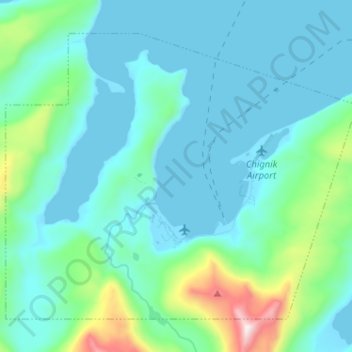
Name: Chignik topographic map, elevation, terrain.

Location: Chignik, Lake and Peninsula, Alaska, 99564, United States (56.27189 -158.46424 56.33406 -158.34507)

Average elevation: 463 ft

Minimum elevation: -10 ft

Maximum elevation: 2,808 ft

Lake and Peninsula trails, hiking, mountain biking, running and outdoor activities

Other topographic maps

Click on a map to view its topography, its elevation and its terrain.

Newhalen

United States > Alaska > Lake and Peninsula > Newhalen

Average elevation: 75 ft

Nondalton

United States > Alaska > Lake and Peninsula > Nondalton

Average elevation: 387 ft

Cinder Cone

United States > Alaska > Lake and Peninsula

Average elevation: 6,047 ft

Sharp Mountain

United States > Alaska > Lake and Peninsula

Average elevation: 1,332 ft

Levelock

United States > Alaska > Lake and Peninsula

Average elevation: 59 ft

Iliamna

United States > Alaska > Lake and Peninsula

Average elevation: 69 ft

Igiugig

United States > Alaska > Lake and Peninsula

Average elevation: 95 ft

Gear up for your next adventure:

🕶️GPS Smartphone Mount - Secure mount for phone navigation
🛶Inflatable Kayak - Portable kayak for rivers, lakes, and expeditions
🛰️Handheld GPS Units - Professional satellite navigators for precise backcountry mapping
🏥Hiking First Aid Kits - Comprehensive medical kits for remote trail injuries
🗺️Topographic Maps - Detailed topo maps for hiking, exploring and outdoor navigation

As an Amazon Associate, this site earns from qualifying purchases at no extra cost to you.