Geolocate

Spanish Springs topographic map

Click on the map to display elevation.

About this map

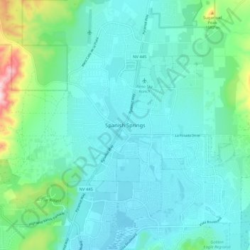
Name: Spanish Springs topographic map, elevation, terrain.

Location: Spanish Springs, Washoe County, Nevada, 89441, United States (39.59948 -119.75038 39.67948 -119.67038)

Average elevation: 4,672 ft

Minimum elevation: 4,446 ft

Maximum elevation: 5,761 ft

Washoe County trails, hiking, mountain biking, running and outdoor activities

Other topographic maps

Click on a map to view its topography, its elevation and its terrain.

Washoe Valley CCD

United States > Nevada > Washoe County

Average elevation: 6,191 ft

Valley Wood Park

United States > Nevada > Washoe County > Reno

Average elevation: 5,072 ft

Virginia Lake

United States > Nevada > Washoe County > Reno

Average elevation: 4,501 ft

Lower Peavine Creek Dam

United States > Nevada > Washoe County > Reno

Average elevation: 4,787 ft

Pyramid Lake

United States > Nevada > Washoe County

Average elevation: 4,613 ft

Sun Valley

United States > Nevada > Washoe County

Average elevation: 4,948 ft

Gear up for your next adventure:

🥾Women's Hiking Boots - Top-rated trail boots with ankle support and superior grip
🔥Fast-Boil Camping Stoves - Efficient cooking systems for quick trail meals
📦Dry Bags Set - Waterproof storage for electronics and clothes
👓Polarized Sunglasses - Outdoor sunglasses for glare reduction
👖Convertible Hiking Pants - Versatile zip-off pants for changing altitudes and temperatures

As an Amazon Associate, this site earns from qualifying purchases at no extra cost to you.