Geolocate

Jacksboro topographic map

Click on the map to display elevation.

About this map

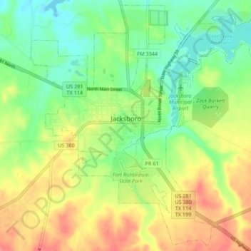
Name: Jacksboro topographic map, elevation, terrain.

Location: Jacksboro, Jack County, Texas, 76458, United States (33.18406 -98.19573 33.25076 -98.11266)

Average elevation: 1,096 ft

Minimum elevation: 994 ft

Maximum elevation: 1,224 ft

Jack County trails, hiking, mountain biking, running and outdoor activities

Other topographic maps

Click on a map to view its topography, its elevation and its terrain.

Bryson

United States > Texas > Jack County

Average elevation: 1,276 ft

Postoak

United States > Texas > Jack County

Average elevation: 1,017 ft

Indian Hills

United States > Texas > Jack County

Average elevation: 1,125 ft

Gear up for your next adventure:

🧢Outdoor Hiking Hat - Sun protection hat for outdoor explorers
🏕️Tent Footprint - Protect your tent base from wear
💧Water Purification System - Clean water on the trail with reliable purifiers
🪶Survival Guide Book - Expert advice for emergency preparedness
❄️Traction Cleats - Prevent slips on icy trails during winter hikes

As an Amazon Associate, this site earns from qualifying purchases at no extra cost to you.