Geolocate

Postoak topographic map

Click on the map to display elevation.

About this map

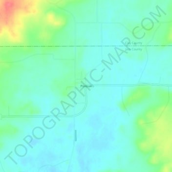
Name: Postoak topographic map, elevation, terrain.

Location: Postoak, Jack County, Texas, United States (33.43705 -98.16310 33.47705 -98.12310)

Average elevation: 1,017 ft

Minimum elevation: 968 ft

Maximum elevation: 1,178 ft

Jack County trails, hiking, mountain biking, running and outdoor activities

Other topographic maps

Click on a map to view its topography, its elevation and its terrain.

Jacksboro

United States > Texas > Jack County

Average elevation: 1,096 ft

Bryson

United States > Texas > Jack County

Average elevation: 1,276 ft

Gear up for your next adventure:

🛰️Handheld GPS Units - Professional satellite navigators for precise backcountry mapping
Solar GPS Watches - Advanced multisport watches with built-in topographic maps
🗺️Topographic Maps - Detailed topo maps for hiking, exploring and outdoor navigation
🥘Titanium Cookware - Durable, featherlight pots and pans for backpacking
🔥Camping Stove - Portable stove for camping and backcountry cooking

As an Amazon Associate, this site earns from qualifying purchases at no extra cost to you.