
Make a donation
Gear up for your next adventure:
As an Amazon Associate, this site earns from qualifying purchases at no extra cost to you.
Tianjin topographic map
Click on the map to display elevation.
Make a donation
Gear up for your next adventure:
As an Amazon Associate, this site earns from qualifying purchases at no extra cost to you.
Tianjin
There is 153 km (95 mi) of coastline and 1,137.48 kilometers (706.80 mi) of land border. It lies at the northern end of the Grand Canal of China, which connects with the Yellow River and Yangtze River. The municipality is generally flat, and swampy near the coast, but hilly in the far north, where the Yan Mountains intrude into northern Tianjin. Extensive tidal flats occur on the coastal plain adjacent to the city. The highest point in the municipality is Jiuding Peak (九顶山) in Ji County on the northern border with Hebei, at an altitude of 1,078.5 m (3,538 ft).
Make a donation
Gear up for your next adventure:
As an Amazon Associate, this site earns from qualifying purchases at no extra cost to you.
About this map
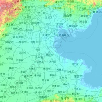
Name: Tianjin topographic map, elevation, terrain.
Location: Tianjin, China (36.57144 113.72830 40.25201 118.05867)
Average elevation: 210 ft
Minimum elevation: -13 ft
Maximum elevation: 8,402 ft
Make a donation
Gear up for your next adventure:
As an Amazon Associate, this site earns from qualifying purchases at no extra cost to you.
Other topographic maps
Click on a map to view its topography, its elevation and its terrain.
Chongqing
The central urban area of Chongqing, or Chongqing proper, is a city of unique features. Built on mountains and partially surrounded by the Yangtze and Jialing rivers, it is known as a "mountain city" and a "city on rivers". The night scene of the city is very illuminated, with millions of lights and their…
Average elevation: 1,043 ft
Shanghai
The golden age of Shanghai began with its elevation to municipality on 7 July 1927. This new Chinese municipality covered an area of 494.69 km2 (191.0 sq mi), including the modern-day districts of Baoshan, Yangpu, Zhabei, Nanshi, and Pudong, but excluded the foreign concessions territories. Headed by a Chinese…
Average elevation: 16 ft
Make a donation
Gear up for your next adventure:
As an Amazon Associate, this site earns from qualifying purchases at no extra cost to you.
Make a donation
Gear up for your next adventure:
As an Amazon Associate, this site earns from qualifying purchases at no extra cost to you.
Make a donation
Gear up for your next adventure:
As an Amazon Associate, this site earns from qualifying purchases at no extra cost to you.
Mount Kailash
China > Tibet > Purang County > Darchen
Mount Kailash (also Kailasa; Kangrinboqê or Gang Rinpoche; Tibetan: གངས་རིན་པོ་ཆེ; simplified Chinese: 冈仁波齐峰; traditional Chinese: 岡仁波齊峰; Sanskrit: कैलास, IAST: Kailāsa), is a mountain in the Ngari Prefecture, Tibet Autonomous Region of China. It has an…
Average elevation: 18,885 ft
Xi'an
China > Shaanxi > Weiyang District > Xi'an
Xi'an lies on the Guanzhong Plain in the south-central part of Shaanxi province, on a flood plain created by the eight surrounding rivers and streams. The city has an average elevation of 400 metres (1,312 ft) above sea level and an annual precipitation of 553 mm (21.8 in). The urban area of Xi'an is located…
Average elevation: 1,352 ft
Qaidam Basin
China > Qinghai > Da Qaidam Administrative Zone > Qaidam
Orographically, the Qaidam Basin is a comparatively low area in the northeastern part of the Tibetan Plateau. With an elevation of around 3,000 m (10,000 ft), Qaidam forms a kind of shelf between Tibet to the south (around 4,300 m or 14,000 ft) and Gansu to the north (around 1,100 m or 3,500 ft). A low water…
Average elevation: 8,996 ft
Make a donation
Gear up for your next adventure:
As an Amazon Associate, this site earns from qualifying purchases at no extra cost to you.
Mount Makalu
China > Tibet > Tingri County > Qutang town
Makalu (Nepali: मकालु हिमाल, romanized: Makālu himāl; Chinese: 马卡鲁峰; pinyin: Mǎkǎlǔ Fēng) is the fifth-highest mountain on Earth, with a summit at an elevation of 8,485 metres (27,838 ft) AMSL. It is located in the Mahalangur Himalayas 19 km (12 mi) southeast of Mount Everest,…
Average elevation: 24,537 ft
Make a donation
Gear up for your next adventure:
As an Amazon Associate, this site earns from qualifying purchases at no extra cost to you.
Make a donation
Gear up for your next adventure:
As an Amazon Associate, this site earns from qualifying purchases at no extra cost to you.
Himalayas
The Himalayas, or Himalaya (/ˌhɪməˈleɪ.ə, hɪˈmɑːləjə/ HIM-ə-LAY-ə, hih-MAH-lə-yə), is a mountain range in Asia, separating the plains of the Indian subcontinent from the Tibetan Plateau. The range has some of the Earth's highest peaks, including the highest, Mount Everest. More than 100 peaks…
Average elevation: 7,825 ft
Make a donation
Gear up for your next adventure:
As an Amazon Associate, this site earns from qualifying purchases at no extra cost to you.
Tianjin
The city has 153 km (95 mi) of coastline and 1,137.48 kilometers (706.80 mi) of land border. It is located at the northern end of the Grand Canal of China, which connects with the Yellow and Yangtze Rivers. The municipality is generally flat and is swampy near the coast; however, it has hills in the north,…
Average elevation: 13 ft
Make a donation
Gear up for your next adventure:
As an Amazon Associate, this site earns from qualifying purchases at no extra cost to you.
Make a donation
Gear up for your next adventure:
As an Amazon Associate, this site earns from qualifying purchases at no extra cost to you.
Make a donation
Gear up for your next adventure:
As an Amazon Associate, this site earns from qualifying purchases at no extra cost to you.
K2
China > Xinjiang > Cenling County
K2 is nicknamed "The King of Mountains" and "The Mountaineers' Mountain", as well as "The Mountain of Mountains", a phrase popularized by Italian climber Reinhold Messner in his book on K2. Although the summit of Everest is at a higher altitude, K2 is a more difficult and dangerous climb. This is in part due…
Average elevation: 24,547 ft
Make a donation
Gear up for your next adventure:
As an Amazon Associate, this site earns from qualifying purchases at no extra cost to you.
Make a donation
Gear up for your next adventure:
As an Amazon Associate, this site earns from qualifying purchases at no extra cost to you.
Victoria Peak
Victoria Peak is a hill on the western half of Hong Kong Island. It is also known as Mount Austin, and locally as The Peak only generally. With an elevation of 552 metres (1,811 ft), it is the tallest hill on Hong Kong Island, and the 29th tallest in the territory of Hong Kong. It is a major tourist attraction…
Average elevation: 686 ft
Xining
China > Qinghai > Renminjie Subdistrict
The city was a commercial hub along the Northern Silk Road's Hexi Corridor for over 2000 years, and was a stronghold of the Han, Sui, Tang, and Song dynasties' resistance against nomadic attacks from the west. Although long a part of Gansu province, Xining was added to Qinghai in 1928. Xining holds sites of…
Average elevation: 8,219 ft
Make a donation
Gear up for your next adventure:
As an Amazon Associate, this site earns from qualifying purchases at no extra cost to you.
Zhangjiajie Tianmen Mountain National Forest Park
China > Hunan > Yongding District
Average elevation: 2,562 ft
Make a donation
Gear up for your next adventure:
As an Amazon Associate, this site earns from qualifying purchases at no extra cost to you.
Broad Peak
China > Xinjiang > Taxkorgan Tajik Autonomous County > Dafdar
Broad Peak is one of the eight-thousanders, and is located in the Karakoram range spanning Gilgit-Baltistan, Pakistan and Xinjiang, China. It is the 12th highest mountain in the world at 8,051 metres (26,414 ft) elevation above sea level. The first ascent of this mountain was in June 1957, accomplished by…
Average elevation: 23,350 ft
Make a donation
Gear up for your next adventure:
As an Amazon Associate, this site earns from qualifying purchases at no extra cost to you.
Beijing
Beijing is situated at the northern tip of the roughly triangular North China Plain, which opens to the south and east of the city. Mountains to the north, northwest and west shield the city and northern China's agricultural heartland from the encroaching desert steppes. The northwestern part of the…
Average elevation: 154 ft
Make a donation
Gear up for your next adventure:
As an Amazon Associate, this site earns from qualifying purchases at no extra cost to you.
Mount Makalu
China > Tibet > Tingri County
Makalu (Nepali: मकालु हिमाल, romanized: Makālu himāl; Chinese: 马卡鲁峰; pinyin: Mǎkǎlǔ Fēng) is the fifth-highest mountain on Earth, with a summit at an elevation of 8,485 metres (27,838 ft) AMSL. It is located in the Mahalangur Himalayas 19 km (12 mi) southeast of Mount Everest,…
Average elevation: 24,537 ft
Himalayas
The Himalayas, or Himalaya, is a mountain range in Asia separating the plains of the Indian subcontinent from the Tibetan Plateau. The range has some of the Earth's highest peaks, including the highest, Mount Everest. More than 100 peaks exceeding elevations of 7,200 metres (23,600 feet) above sea level lie in…
Average elevation: 7,825 ft
Make a donation
Gear up for your next adventure:
As an Amazon Associate, this site earns from qualifying purchases at no extra cost to you.
Jiuzhaigou
China > Sichuan > Jiuzhaigou County
The county consists of nine villages in a valley in Sichuan Province. The main ethnic group in the county is Han, with the second being Tibetan. The county seat has an altitude of about 1,400 m (4,600 ft).[1] It has a total area of 2,041 square miles (5,286 km2).[2] As of 2015, the county's total population…
Average elevation: 8,268 ft
Make a donation
Gear up for your next adventure:
As an Amazon Associate, this site earns from qualifying purchases at no extra cost to you.
Hubei
The Jianghan Plain takes up most of central and southern Hubei, while the west and the peripheries are more mountainous, with ranges such as the Wudang Mountains, the Jing Mountains, the Daba Mountains, and the Wu Mountains (in rough north-to-south order). The Dabie Mountains lie to the northeast of the…
Average elevation: 1,368 ft
Zhangye Danxia National Geological Park
China > Gansu > Linze County > Nantai
Average elevation: 5,771 ft
Victoria Peak
China > Hong Kong > Hong Kong Island
Victoria Peak is a hill on the western half of Hong Kong Island. It is also known as Mount Austin, and locally as The Peak only generally. With an elevation of 552 metres (1,811 ft), it is the tallest hill on Hong Kong Island, and the 29th tallest in the territory of Hong Kong. It is a major tourist attraction…
Average elevation: 686 ft
Himalayas
The Himalayas, or Himalaya, is a mountain range in Asia separating the plains of the Indian subcontinent from the Tibetan Plateau. The range has some of the Earth's highest peaks, including the highest, Mount Everest. More than 100 peaks exceeding elevations of 7,200 m (23,600 ft) above sea level lie in the…
Average elevation: 7,825 ft
Make a donation
Gear up for your next adventure:
As an Amazon Associate, this site earns from qualifying purchases at no extra cost to you.
Taipa Central Park
China > Macau > 嘉模堂區 Nossa Senhora do Carmo > 花城 Cidade das Flores
Average elevation: 36 ft
Make a donation
Gear up for your next adventure:
As an Amazon Associate, this site earns from qualifying purchases at no extra cost to you.
Himalayas
The Himalayas, or Himalaya (/ˌhɪməˈleɪ.ə, hɪˈmɑːləjə/ HIM-ə-LAY-ə, hih-MAH-lə-yə), is a mountain range in Asia, separating the plains of the Indian subcontinent from the Tibetan Plateau. The range has some of the Earth's highest peaks, including the highest, Mount Everest. More than 100 peaks…
Average elevation: 7,825 ft
Make a donation
Gear up for your next adventure:
As an Amazon Associate, this site earns from qualifying purchases at no extra cost to you.
Make a donation
Gear up for your next adventure:
As an Amazon Associate, this site earns from qualifying purchases at no extra cost to you.
Tai Mo Shan
China > Hong Kong > Tsuen Wan District
Tai Mo Shan is the highest peak in Hong Kong, with an elevation of 957 metres (3,140 ft) above the Hong Kong Principal Datum [zh], or around 956 metres (3,136 ft) above mean sea level. It is located at approximately the geographical centre of the New Territories.
Average elevation: 1,969 ft
Make a donation
Gear up for your next adventure:
As an Amazon Associate, this site earns from qualifying purchases at no extra cost to you.
Amur
China > Heilongjiang > Fuyuan City > Fuyuan
The river rises in the hills in the western part of Northeast China at the confluence of its two major affluents, the Shilka and the Argun (or Ergune), at an elevation of 303 metres (994 ft). It flows east forming the border between China and Russia, and slowly makes a great arc to the southeast for about 400…
Average elevation: 151 ft
Qingdao
Qingdao is located on the south facing coast of the Shandong Peninsula (German: Schantung Halbinsel). It borders three prefecture-level cities, namely Yantai to the northeast, Weifang to the west, and Rizhao to the southwest. The city's total jurisdiction area occupies 10,654 square kilometres (4,114 sq mi),…
Average elevation: 82 ft
Make a donation
Gear up for your next adventure:
As an Amazon Associate, this site earns from qualifying purchases at no extra cost to you.