
Longmen topographic map
Click on the map to display elevation.
About this map
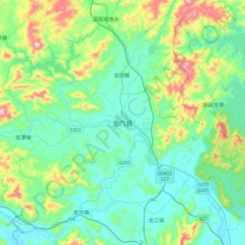
Name: Longmen topographic map, elevation, terrain.
Location: Longmen, Huizhou, Guangdong, China (23.57049 114.09006 23.89049 114.41006)
Average elevation: 623 ft
Minimum elevation: 112 ft
Maximum elevation: 2,461 ft
Other topographic maps
Click on a map to view its topography, its elevation and its terrain.
Guangzhou City
The elevation of the prefecture generally increases from southwest to northeast, with mountains forming the backbone of the city and the ocean comprising the front. Tiantang Peak is the highest point of elevation at 1,210 metres (3,970 feet) above sea level.
Average elevation: 322 ft
Guangzhou City
The elevation of the prefecture generally increases from southwest to northeast, with mountains forming the backbone of the city and the ocean comprising the front. Tiantang Peak is the highest point of elevation at 1,210 metres (3,970 feet) above sea level.
Average elevation: 322 ft
Guangzhou City
The elevation of the prefecture generally increases from southwest to northeast, with mountains forming the backbone of the city and the ocean comprising the front. Tiantang Peak (simplified Chinese: 天堂顶; traditional Chinese: 天堂頂, "Heavenly Peak") is the highest point of elevation at 1,210 m (3,970…
Average elevation: 322 ft
Chaozhou
The Chaozhou territory is mountainous. In particular, the nearby Phoenix Mountain's peak is located 1,497 meters (4,911 ft) above sea level. The main nearby rivers are the Huanggang River and the Han River. The Han River flows from west to southeast, and ramps through downtown Chaozhou; the Huanggang river…
Average elevation: 751 ft
Qingyuan City
Qingyuan's administrative area ranges in latitude from 23° 26' 56" to 25° 11' 40" N, and in longitude from 111° 55' 17" to 113° 55' 34" E; its urban area is located just north of the Tropic of Cancer, about 60 km (37 mi) from the urban area of Guangzhou and 200 km (120 mi) from both Hong Kong and Macau.…
Average elevation: 1,145 ft
Guangzhou City
The elevation of the prefecture generally increases from southwest to northeast, with mountains forming the backbone of the city and the ocean comprising the front. Tiantang Peak is the highest point of elevation at 1,210 metres (3,970 feet) above sea level.
Average elevation: 322 ft
Guangzhou City
The elevation of the prefecture generally increases from southwest to northeast, with mountains forming the backbone of the city and the ocean comprising the front. Tiantang Peak (simplified Chinese: 天堂顶; traditional Chinese: 天堂頂, "Heavenly Peak") is the highest point of elevation at 1,210 m (3,970…
Average elevation: 322 ft
Nanshan District
At 587 metres (1,926 ft) tall, Yangtaishan has the highest elevation in the district, with Tanglangshan being the second at 430 metres (1,411 ft), and Nanshan, third, at 336 metres (1,102 ft). The district has a total coastline of 55.18 kilometres (34.29 mi).
Average elevation: 115 ft
Chancheng District
The district lies at the center of Foshan, surrounded on the east, west, and north sides by the Nanhai District and bordered to the south by the Shunde District. Chancheng District is located in the hinterland of the Pearl River Delta, southwest of Guangzhou and central Foshan, bordering Nanhai District to the…
Average elevation: 16 ft
Nanshan District
At 587 metres (1,926 ft) tall, Yangtaishan has the highest elevation in the district, with Tanglangshan being the second at 430 metres (1,411 ft), and Nanshan, third, at 336 metres (1,102 ft). The district has a total coastline of 55.18 kilometres (34.29 mi).
Average elevation: 115 ft