Geolocate

Western Grove topographic map

Click on the map to display elevation.

About this map

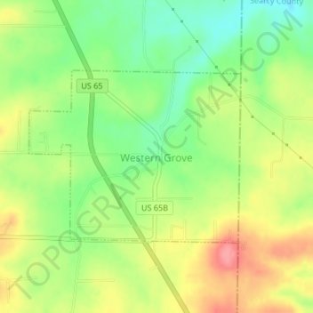
Name: Western Grove topographic map, elevation, terrain.

Location: Western Grove, Newton County, Arkansas, 72685, United States (36.09352 -92.96743 36.10844 -92.94475)

Average elevation: 1,125 ft

Minimum elevation: 991 ft

Maximum elevation: 1,273 ft

Newton County trails, hiking, mountain biking, running and outdoor activities

Other topographic maps

Click on a map to view its topography, its elevation and its terrain.

Big Bluff

United States > Arkansas > Newton County

Average elevation: 1,302 ft

Ryker

United States > Arkansas > Newton County

Average elevation: 2,103 ft

Nail

United States > Arkansas > Newton County

Average elevation: 1,919 ft

Hasty

United States > Arkansas > Newton County

Average elevation: 1,106 ft

Buffalo River

United States > Arkansas > Newton County

Average elevation: 1,417 ft

Lurton

United States > Arkansas > Newton County > Lurton

Average elevation: 1,900 ft

Deer

United States > Arkansas > Newton County

Average elevation: 2,096 ft

Gear up for your next adventure:

🦺Reflective Outdoor Gear - Safety gear for low‑light conditions
🌡️Handheld Weather Meters - Measure wind, temp, and pressure for safe mountain travel
📻Weather Alert Radios - Stay informed of storm risks while off-the-grid
🏕️Family Camping Gear - Essentials for group camping trips
📷Action Cameras - Rugged cameras to document your journeys across rugged terrain

As an Amazon Associate, this site earns from qualifying purchases at no extra cost to you.