
Make a donation
Gear up for your next adventure:
As an Amazon Associate, this site earns from qualifying purchases at no extra cost to you.
Shalë topographic map
Click on the map to display elevation.
Make a donation
Gear up for your next adventure:
As an Amazon Associate, this site earns from qualifying purchases at no extra cost to you.
About this map
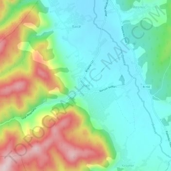
Name: Shalë topographic map, elevation, terrain.
Location: Shalë, Municipality of Lipljan, Kosovo (42.48386 20.89815 42.52386 20.93815)
Average elevation: 2,362 ft
Minimum elevation: 1,975 ft
Maximum elevation: 3,140 ft
Make a donation
Gear up for your next adventure:
As an Amazon Associate, this site earns from qualifying purchases at no extra cost to you.
Other topographic maps
Click on a map to view its topography, its elevation and its terrain.
Make a donation
Gear up for your next adventure:
As an Amazon Associate, this site earns from qualifying purchases at no extra cost to you.
Make a donation
Gear up for your next adventure:
As an Amazon Associate, this site earns from qualifying purchases at no extra cost to you.
Fushë Kosovë
Kosovo Polje is a municipality that lies in the center of the Kosovo Plain, with an area of 84 km2 (32 sq mi) and an altitude of 540 m (1,772 ft) above sea level. The city is situated between Pristina in the east, Obiliq in the north, Gračanica in the south and Drenas in the west. It consists of 16…
Average elevation: 1,808 ft
Make a donation
Gear up for your next adventure:
As an Amazon Associate, this site earns from qualifying purchases at no extra cost to you.