Geolocate

Shalë topographic map

Click on the map to display elevation.

About this map

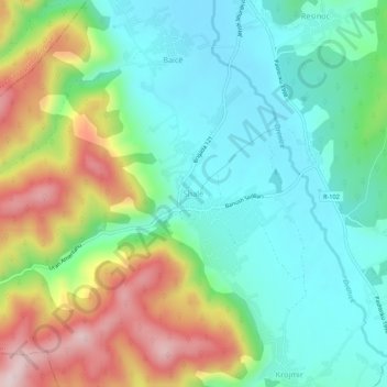
Name: Shalë topographic map, elevation, terrain.

Location: Shalë, Municipality of Lipljan, Kosovo (42.48386 20.89815 42.52386 20.93815)

Average elevation: 2,362 ft

Minimum elevation: 1,975 ft

Maximum elevation: 3,140 ft

Other topographic maps

Click on a map to view its topography, its elevation and its terrain.

Municipality of Zvečan

Kosovo

Average elevation: 2,539 ft

Mitrovica Municipality

Kosovo

Average elevation: 2,789 ft

Lipjan

Kosovo

Average elevation: 1,818 ft

Municipality of Leposavić

Kosovo

Average elevation: 3,058 ft

Kuqishtë

Kosovo

Average elevation: 4,993 ft

Lakrishtë

Kosovo > Municipality of Pristina > Pristina

Average elevation: 1,978 ft

Municipality of Pristina

Kosovo

Average elevation: 2,477 ft

Qyteza Pejton

Kosovo > Municipality of Pristina > Pristina

Average elevation: 1,998 ft

Sllovi

Kosovo

Average elevation: 2,149 ft

District of Ferizaj

Kosovo

Average elevation: 3,012 ft

Bob

Kosovo

Average elevation: 2,001 ft

Gear up for your next adventure:

🪶Wildlife Field Guides - Learn animal tracking and species ID
🛶Inflatable Kayak - Portable kayak for rivers, lakes, and expeditions
🪶Multi‑Purpose Knife - Useful blade for camp and trail
🧯Emergency Survival Kit - All‑in‑one survival essentials for the backcountry
📻Weather Alert Radios - Stay informed of storm risks while off-the-grid

As an Amazon Associate, this site earns from qualifying purchases at no extra cost to you.