
Municipality of Pristina topographic map
Interactive map
Click on the map to display elevation.
About this map
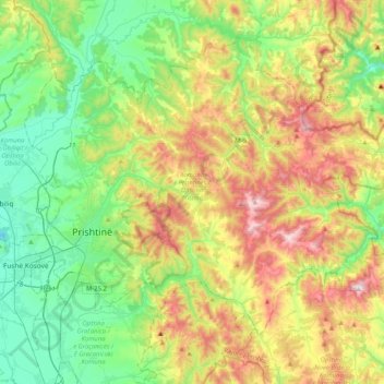
Name: Municipality of Pristina topographic map, elevation, terrain.
Location: Municipality of Pristina, Kosovo (42.57339 21.09099 42.81656 21.50095)
Average elevation: 2,477 ft
Minimum elevation: 1,594 ft
Maximum elevation: 4,111 ft
Other topographic maps
Click on a map to view its topography, its elevation and its terrain.
Mitrovica Municipality
Mitrovica Municipality, District of Mitrovica, Kosovo
Average elevation: 2,789 ft
Municipality of Zvečan
Municipality of Zvečan, District of Mitrovica, 38227, Kosovo
Average elevation: 2,539 ft
North Mitrovica
Kosovo > Severna Kosovska Mitrovica / Mitrovicë Veriore
North Mitrovica, Severna Kosovska Mitrovica / Mitrovicë Veriore, Municipality of North Mitrovica, District of Mitrovica, 38220, Kosovo
Average elevation: 2,021 ft
Terpezë
Kosovo > Municipality of Vitina
Terpezë, Municipality of Vitina, 61000, Kosovo
Average elevation: 1,955 ft
Barilevë
Kosovo > Municipality of Pristina
Barilevë, Municipality of Pristina, 10520, Kosovo
Average elevation: 1,890 ft
Popova šapka (2075)
Popova šapka (2075), Municipality of Dragash / Dragaš, Kosovo
Average elevation: 6,135 ft
Lakrishtë
Kosovo > Municipality of Pristina > Pristina
Lakrishtë, Pristina, Municipality of Pristina, Kosovo
Average elevation: 1,978 ft
Qyteza Pejton
Kosovo > Municipality of Pristina > Pristina
Qyteza Pejton, Pristina, Municipality of Pristina, Kosovo
Average elevation: 1,998 ft
Fushë Kosovë
Fushë Kosovë, Municipality of Fushë Kosovë / Kosovo Polje, Kosovo
Average elevation: 1,808 ft
Kolovicë
Kosovo > Municipality of Pristina
Kolovicë, Municipality of Pristina, 10010, Kosovo
Average elevation: 2,392 ft
Çagllavicë (Prishtinë)
Çagllavicë (Prishtinë), Municipality of Pristina, District of Prishtina, 10150, Kosovo
Average elevation: 1,942 ft
Pristina
Kosovo > Municipality of Pristina > Pristina
Pristina, Municipality of Pristina, 10000, Kosovo
Average elevation: 2,280 ft
Matiqan
Kosovo > Municipality of Pristina > Matiqan
Matiqan, Municipality of Pristina, Kosovo
Average elevation: 2,254 ft
Bardh i Madh
Bardh i Madh, Municipality of Fushë Kosovë / Kosovo Polje, District of Prishtina, 12060, Kosovo
Average elevation: 1,906 ft
Han i Elezit
Han i Elezit, Municipality of Han i Elezit / Elez Han, 71510, Kosovo
Average elevation: 1,512 ft