Geolocate

Zerba topographic map

Click on the map to display elevation.

About this map

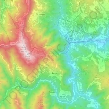
Name: Zerba topographic map, elevation, terrain.

Location: Zerba, Piacenza, Emilia-Romagna, Italy (44.64472 9.19914 44.71420 9.30999)

Average elevation: 2,782 ft

Minimum elevation: 1,165 ft

Maximum elevation: 5,584 ft

Other topographic maps

Click on a map to view its topography, its elevation and its terrain.

Crocinito

Italy > Emilia-Romagna > Piacenza

Average elevation: 1,854 ft

Bogli

Italy > Emilia-Romagna > Piacenza > Ottone

Average elevation: 3,898 ft

Misano

Italy > Emilia-Romagna > Piacenza > Agazzano

Average elevation: 787 ft

Sariano

Italy > Emilia-Romagna > Piacenza > Gropparello

Average elevation: 873 ft

Fiorano

Italy > Emilia-Romagna > Piacenza > Travo

Average elevation: 932 ft

Capannette di Pej

Italy > Emilia-Romagna > Piacenza > Zerba

Average elevation: 4,304 ft

Dadomo

Italy > Emilia-Romagna > Piacenza > Vernasca

Average elevation: 2,264 ft

Gear up for your next adventure:

🏔️Mountain Trail Maps - High‑detail maps for popular peaks
🧷Carabiner Set - Durable clips for gear attachment
🪓Survival Multi‑Tool - Versatile tool for camp and trail tasks
🧭GPS Watch Accessories - Bands and chargers for GPS watches
🌡️Portable Weather Meter - Track weather conditions on the trail

As an Amazon Associate, this site earns from qualifying purchases at no extra cost to you.