Geolocate

Crocinito topographic map

Click on the map to display elevation.

About this map

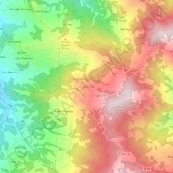
Name: Crocinito topographic map, elevation, terrain.

Location: Crocinito, Bettola, Piacenza, Emilia-Romagna, Italy (44.78019 9.52176 44.82019 9.56176)

Average elevation: 1,854 ft

Minimum elevation: 856 ft

Maximum elevation: 2,772 ft

Other topographic maps

Click on a map to view its topography, its elevation and its terrain.

Bobbio

Italy > Emilia-Romagna > Piacenza

Average elevation: 2,369 ft

Corte Brugnatella

Italy > Emilia-Romagna > Piacenza

Average elevation: 2,369 ft

Ottone

Italy > Emilia-Romagna > Piacenza

Average elevation: 2,904 ft

Piacenza

Italy > Emilia-Romagna > Piacenza

Average elevation: 197 ft

Bettola

Italy > Emilia-Romagna > Piacenza

Average elevation: 2,064 ft

Caorso

Italy > Emilia-Romagna > Piacenza

Average elevation: 148 ft

Travo

Italy > Emilia-Romagna > Piacenza

Average elevation: 1,276 ft

Piacenza

Italy > Emilia-Romagna > Piacenza

Average elevation: 197 ft

Zerba

Italy > Emilia-Romagna > Piacenza

Average elevation: 2,782 ft

Gazzola

Italy > Emilia-Romagna > Piacenza

Average elevation: 732 ft

Borgonovo Val Tidone

Italy > Emilia-Romagna > Piacenza

Average elevation: 489 ft

Ottone

Italy > Emilia-Romagna > Piacenza

Average elevation: 2,904 ft

Castel San Giovanni

Italy > Emilia-Romagna > Piacenza

Average elevation: 266 ft

Ferriere

Italy > Emilia-Romagna > Piacenza

Average elevation: 3,235 ft

Gear up for your next adventure:

🧦Hiking Socks - Comfortable socks to prevent blisters on long hikes
🕶️GPS Smartphone Mount - Secure mount for phone navigation
🧭Map Reading Tools - Tools and kits for map navigation
🪶Fire Starter Kit - Reliable fire starter for survival and camping
🌎3D Topographic Globes - Raised relief globes for a tactile understanding of geography

As an Amazon Associate, this site earns from qualifying purchases at no extra cost to you.