Geolocate

Reno topographic map

Click on the map to display elevation.

About this map

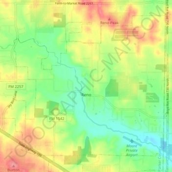
Name: Reno topographic map, elevation, terrain.

Location: Reno, Parker County, Texas, United States (32.92045 -97.62218 32.97482 -97.54357)

Average elevation: 764 ft

Minimum elevation: 650 ft

Maximum elevation: 906 ft

Parker County trails, hiking, mountain biking, running and outdoor activities

Other topographic maps

Click on a map to view its topography, its elevation and its terrain.

Poolville

United States > Texas > Parker County

Average elevation: 1,175 ft

Sabathany

United States > Texas > Parker County

Average elevation: 860 ft

Peaster

United States > Texas > Parker County

Average elevation: 1,204 ft

Snake Forest

United States > Texas > Parker County

Average elevation: 1,024 ft

Whitt

United States > Texas > Parker County

Average elevation: 1,112 ft

Authon

United States > Texas > Parker County

Average elevation: 1,043 ft

Slipdown Mountain

United States > Texas > Parker County

Average elevation: 1,280 ft

Brock

United States > Texas > Parker County

Average elevation: 866 ft

Dennis

United States > Texas > Parker County

Average elevation: 764 ft

Agnes

United States > Texas > Parker County

Average elevation: 1,152 ft

Garner

United States > Texas > Parker County

Average elevation: 971 ft

Reno

United States > Texas > Parker County > Reno > Reno

Average elevation: 741 ft

Gear up for your next adventure:

🌧️Backpack Rain Cover - Keep gear dry in wet weather
🧭Orienteering Set - Complete compass and map reading kit
📦Dry Bags Set - Waterproof storage for electronics and clothes
GPS Sports Watch - GPS watch for running, hiking and training
🪓Survival Multi‑Tool - Versatile tool for camp and trail tasks

As an Amazon Associate, this site earns from qualifying purchases at no extra cost to you.