Geolocate

Dennis topographic map

Click on the map to display elevation.

About this map

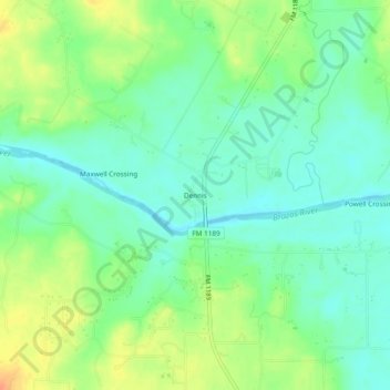
Name: Dennis topographic map, elevation, terrain.

Location: Dennis, Parker County, Texas, United States (32.59874 -97.94670 32.63874 -97.90670)

Average elevation: 764 ft

Minimum elevation: 712 ft

Maximum elevation: 853 ft

Other topographic maps

Click on a map to view its topography, its elevation and its terrain.

Weatherford

United States > Texas > Parker County

Average elevation: 1,070 ft

Reno

United States > Texas > Parker County

Average elevation: 764 ft

Aledo

United States > Texas > Parker County

Average elevation: 889 ft

Springtown

United States > Texas > Parker County

Average elevation: 896 ft

Millsap

United States > Texas > Parker County

Average elevation: 843 ft

Snake Forest

United States > Texas > Parker County

Average elevation: 1,024 ft

Aledo

United States > Texas > Parker County

Average elevation: 889 ft

Weatherford

United States > Texas > Parker County

Average elevation: 1,070 ft

Gear up for your next adventure:

📱Solar Portable Charger - Solar power bank for charging devices off‑grid
🚁Photography Drones - Capture stunning aerial views of landforms and topography
🪶Paracord Bracelet - Survival bracelet with built‑in tools
Camping Coffee Makers - Enjoy premium coffee at the summit or campsite
🎒Waterproof Dry Bags - Keep your electronics and maps dry inside your pack

As an Amazon Associate, this site earns from qualifying purchases at no extra cost to you.