Geolocate

Hamilton Township topographic map

Click on the map to display elevation.

About this map

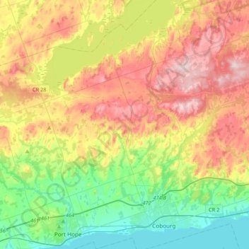
Name: Hamilton Township topographic map, elevation, terrain.

Location: Hamilton Township, Northumberland County, Central Ontario, Ontario, Canada (43.93750 -78.34658 44.17248 -78.07972)

Average elevation: 630 ft

Minimum elevation: 230 ft

Maximum elevation: 1,165 ft

Other topographic maps

Click on a map to view its topography, its elevation and its terrain.

Warkworth

Canada > Ontario > Northumberland County > Trent Hills

Average elevation: 541 ft

Alderville

Canada > Ontario > Northumberland County

Average elevation: 850 ft

Trent River

Canada > Ontario > Northumberland County > Trent Hills

Average elevation: 453 ft

Campbellford

Canada > Ontario > Northumberland County > Trent Hills

Average elevation: 571 ft

Morganston

Canada > Ontario > Northumberland County > Cramahe

Average elevation: 554 ft

Colborne

Canada > Ontario > Northumberland County > Cramahe

Average elevation: 374 ft

Zion

Canada > Ontario > Northumberland County > Port Hope

Average elevation: 597 ft

Hastings

Canada > Ontario > Northumberland County > Trent Hills

Average elevation: 679 ft

Campbellcroft

Canada > Ontario > Northumberland County > Port Hope

Average elevation: 679 ft

Garden Hill

Canada > Ontario > Northumberland County > Port Hope

Average elevation: 650 ft

Percy Boom

Canada > Ontario > Northumberland County > Trent Hills

Average elevation: 417 ft

Castleton

Canada > Ontario > Northumberland County > Cramahe

Average elevation: 656 ft

Hardy Island

Canada > Ontario > Northumberland County > Trent Hills

Average elevation: 614 ft

Colborne

Canada > Ontario > Northumberland County > Cramahe

Average elevation: 374 ft

Gear up for your next adventure:

🧭Orienteering Set - Complete compass and map reading kit
🔌USB Car Charger - Car charger for on‑the‑go power needs
🛰️Satellite Messengers - Emergency SOS and two-way messaging for off-grid adventures
🏕️Tent Footprint - Protect your tent base from wear
🗺️NatGeo Topo Maps - High-quality waterproof printed topographic maps of US Parks

As an Amazon Associate, this site earns from qualifying purchases at no extra cost to you.