Geolocate

Camden topographic map

Click on the map to display elevation.

About this map

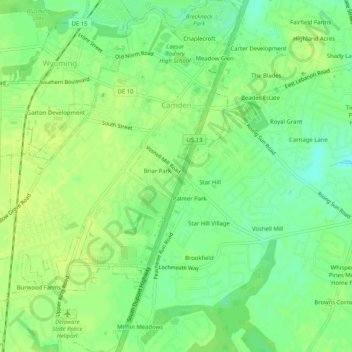
Name: Camden topographic map, elevation, terrain.

Location: Camden, Kent County, Delaware, United States (39.08558 -75.57058 39.12526 -75.53248)

Average elevation: 43 ft

Minimum elevation: 7 ft

Maximum elevation: 62 ft

Kent County trails, hiking, mountain biking, running and outdoor activities

Other topographic maps

Click on a map to view its topography, its elevation and its terrain.

Lebanon

United States > Delaware > Kent County > Highland Acres

Average elevation: 23 ft

Vernon

United States > Delaware > Kent County

Average elevation: 52 ft

Dover Base

United States > Delaware > Kent County

Average elevation: 16 ft

Lebanon

United States > Delaware > Kent County > Highland Acres

Average elevation: 23 ft

Holletts Corners

United States > Delaware > Kent County

Average elevation: 69 ft

Woodstock Court

United States > Delaware > Kent County > Dover

Average elevation: 43 ft

Marydel

United States > Delaware > Kent County

Average elevation: 62 ft

Lake Bernard

United States > Delaware > Kent County > Florence

Average elevation: 13 ft

Gear up for your next adventure:

🪑Portable Camp Table - Compact table for campsite meals
🔋Rechargeable Batteries - Power up your outdoor devices
📻Weather Alert Radios - Stay informed of storm risks while off-the-grid
🧥Waterproof Jacket for Hiking - Breathable and rugged rain jacket for outdoor excursions
🛏️Cold Weather Sleeping Bag - Warm sleeping bag for cold conditions

As an Amazon Associate, this site earns from qualifying purchases at no extra cost to you.