
Make a donation
Gear up for your next adventure:
As an Amazon Associate, this site earns from qualifying purchases at no extra cost to you.
Combarbalá topographic map
Click on the map to display elevation.
Make a donation
Gear up for your next adventure:
As an Amazon Associate, this site earns from qualifying purchases at no extra cost to you.
About this map
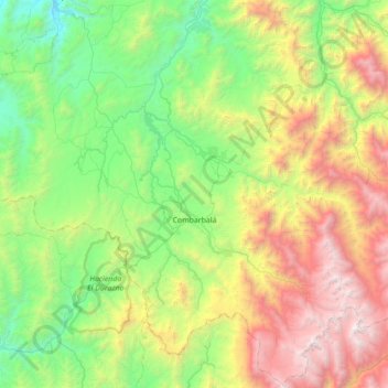
Name: Combarbalá topographic map, elevation, terrain.
Average elevation: 4,738 ft
Minimum elevation: 741 ft
Maximum elevation: 13,488 ft
Make a donation
Gear up for your next adventure:
As an Amazon Associate, this site earns from qualifying purchases at no extra cost to you.
Other topographic maps
Click on a map to view its topography, its elevation and its terrain.
Cerrillos de Tamaya
Chile > Región de Coquimbo > Provincia de Limarí > Ovalle
Average elevation: 840 ft
Valle Hermoso
Chile > Región de Coquimbo > Provincia de Limarí > Combarbalá
Average elevation: 4,042 ft
Make a donation
Gear up for your next adventure:
As an Amazon Associate, this site earns from qualifying purchases at no extra cost to you.
Embalse Recoleta
Chile > Región de Coquimbo > Provincia de Limarí > Ovalle
Average elevation: 1,716 ft
Make a donation
Gear up for your next adventure:
As an Amazon Associate, this site earns from qualifying purchases at no extra cost to you.
Make a donation
Gear up for your next adventure:
As an Amazon Associate, this site earns from qualifying purchases at no extra cost to you.
Mialqui
Chile > Región de Coquimbo > Provincia de Limarí > Monte Patria > Chilecito
Average elevation: 2,293 ft
Make a donation
Gear up for your next adventure:
As an Amazon Associate, this site earns from qualifying purchases at no extra cost to you.
Las Mollacas
Chile > Región de Coquimbo > Provincia de Limarí > Monte Patria
Average elevation: 4,396 ft
Make a donation
Gear up for your next adventure:
As an Amazon Associate, this site earns from qualifying purchases at no extra cost to you.
La Puntilla
Chile > Región de Coquimbo > Provincia de Limarí > Río Hurtado > Pichasca
Average elevation: 2,799 ft
Make a donation
Gear up for your next adventure:
As an Amazon Associate, this site earns from qualifying purchases at no extra cost to you.
Embalse Valle Hermoso
Chile > Región de Coquimbo > Provincia de Limarí > Combarbalá
Average elevation: 5,594 ft
Río Mostazal
Chile > Región de Coquimbo > Provincia de Limarí > Monte Patria
Average elevation: 5,413 ft
Make a donation
Gear up for your next adventure:
As an Amazon Associate, this site earns from qualifying purchases at no extra cost to you.
Potrerillos
Chile > Región de Coquimbo > Provincia de Limarí > Combarbalá > Potrerillos
Average elevation: 3,665 ft
Make a donation
Gear up for your next adventure:
As an Amazon Associate, this site earns from qualifying purchases at no extra cost to you.
Pejerreyes
Chile > Región de Coquimbo > Provincia de Limarí > Monte Patria
Average elevation: 5,591 ft
Chañaral Alto
Chile > Región de Coquimbo > Provincia de Limarí > Monte Patria
Average elevation: 1,883 ft
La Cisterna
Chile > Región de Coquimbo > Provincia de Limarí > Monte Patria > Tulahuén > La Cisterna
Average elevation: 3,770 ft
Altar Bajo
Chile > Región de Coquimbo > Provincia de Limarí > Punitaqui > Altar Bajo
Average elevation: 2,707 ft
Make a donation
Gear up for your next adventure:
As an Amazon Associate, this site earns from qualifying purchases at no extra cost to you.
Potrerillos Altos
Chile > Región de Coquimbo > Provincia de Limarí > Ovalle > Nueva Aurora > Potrerillos Altos
Average elevation: 1,112 ft
La Cebada
Chile > Región de Coquimbo > Provincia de Limarí > Ovalle > La Cebada
Average elevation: 276 ft
Make a donation
Gear up for your next adventure:
As an Amazon Associate, this site earns from qualifying purchases at no extra cost to you.
Cuestecita
Chile > Región de Coquimbo > Provincia de Limarí > Monte Patria
Average elevation: 5,082 ft
Make a donation
Gear up for your next adventure:
As an Amazon Associate, this site earns from qualifying purchases at no extra cost to you.
Las Higueras
Chile > Región de Coquimbo > Provincia de Limarí > Monte Patria
Average elevation: 6,033 ft
El Codito
Chile > Región de Coquimbo > Provincia de Limarí > Combarbalá > Cogotí
Average elevation: 2,858 ft